You are here: Home > Network List > US - United States National Seismic Network Stations List
> Station ELK Elko, Nevada, USA > Earthquake Result Viewer
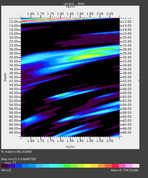
ELK Elko, Nevada, USA - Earthquake Result Viewer
| Earthquake location: |
Near West Coast Of Honshu, Japan |
| Earthquake latitude/longitude: |
37.5/138.4 |
| Earthquake time(UTC): |
2007/07/16 (197) 01:13:22 GMT |
| Earthquake Depth: |
12 km |
| Earthquake Magnitude: |
6.5 MB, 6.4 MS, 6.6 MW, 6.5 MW |
| Earthquake Catalog/Contributor: |
WHDF/NEIC |
|
| Network: |
US United States National Seismic Network |
| Station: |
ELK Elko, Nevada, USA |
| Lat/Lon: |
40.74 N/115.24 W |
| Elevation: |
2210 m |
|
| Distance: |
77.0 deg |
| Az: |
48.447 deg |
| Baz: |
308.466 deg |
| Ray Param: |
0.050605975 |
| Estimated Moho Depth: |
10.5 km |
| Estimated Crust Vp/Vs: |
1.77 |
| Assumed Crust Vp: |
6.276 km/s |
| Estimated Crust Vs: |
3.546 km/s |
| Estimated Crust Poisson's Ratio: |
0.27 |
|
| Radial Match: |
95.83898 % |
| Radial Bump: |
400 |
| Transverse Match: |
93.52045 % |
| Transverse Bump: |
314 |
| SOD ConfigId: |
2564 |
| Insert Time: |
2010-03-05 07:15:18.325 +0000 |
| GWidth: |
2.5 |
| Max Bumps: |
400 |
| Tol: |
0.001 |
|

Signal To Noise
| Channel | StoN | STA | LTA |
| US:ELK: :BHN:20070716T01:24:43.622014Z | 13.1149235 | 3.3362002E-7 | 2.5438199E-8 |
| US:ELK: :BHE:20070716T01:24:43.622014Z | 14.492817 | 4.0617854E-7 | 2.8026196E-8 |
| US:ELK: :BHZ:20070716T01:24:43.622014Z | 32.53203 | 2.1852104E-6 | 6.717105E-8 |
| Arrivals |
| Ps | 1.3 SECOND |
| PpPs | 4.5 SECOND |
| PsPs/PpSs | 5.8 SECOND |


