You are here: Home > Network List > US - United States National Seismic Network Stations List
> Station ELK Elko, Nevada, USA > Earthquake Result Viewer
ELK Elko, Nevada, USA - Earthquake Result Viewer
| Earthquake location: |
Solomon Islands |
| Earthquake latitude/longitude: |
-8.4/157.0 |
| Earthquake time(UTC): |
2007/04/06 (096) 09:12:19 GMT |
| Earthquake Depth: |
9.2 km |
| Earthquake Magnitude: |
5.5 MB, 5.1 MS, 5.4 MW |
| Earthquake Catalog/Contributor: |
WHDF/NEIC |
|
| Network: |
US United States National Seismic Network |
| Station: |
ELK Elko, Nevada, USA |
| Lat/Lon: |
40.74 N/115.24 W |
| Elevation: |
2210 m |
|
| Distance: |
93.7 deg |
| Az: |
49.531 deg |
| Baz: |
262.204 deg |
| Ray Param: |
0.041213904 |
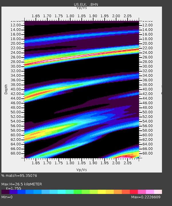
| Estimated Moho Depth: |
26.5 km |
| Estimated Crust Vp/Vs: |
1.75 |
| Assumed Crust Vp: |
6.276 km/s |
| Estimated Crust Vs: |
3.576 km/s |
| Estimated Crust Poisson's Ratio: |
0.26 |
|
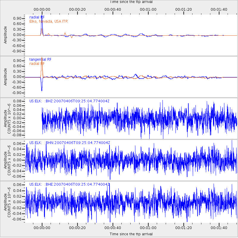
| Radial Match: |
95.35076 % |
| Radial Bump: |
249 |
| Transverse Match: |
76.779526 % |
| Transverse Bump: |
370 |
| SOD ConfigId: |
2564 |
| Insert Time: |
2010-03-05 07:15:27.625 +0000 |
| GWidth: |
2.5 |
| Max Bumps: |
400 |
| Tol: |
0.001 |
|
Signal To Noise
| Channel | StoN | STA | LTA |
| US:ELK: :BHN:20070406T09:25:04.774004Z | 0.91577196 | 1.8456133E-8 | 2.0153633E-8 |
| US:ELK: :BHE:20070406T09:25:04.774004Z | 0.9713013 | 1.9345036E-8 | 1.9916616E-8 |
| US:ELK: :BHZ:20070406T09:25:04.774004Z | 1.0154483 | 2.7313206E-8 | 2.6897684E-8 |
| Arrivals |
| Ps | 3.3 SECOND |
| PpPs | 11 SECOND |
| PsPs/PpSs | 15 SECOND |


