You are here: Home > Network List > AE - Arizona Broadband Seismic Network Stations List
> Station U15A North Rim, AZ, USA > Earthquake Result Viewer
U15A North Rim, AZ, USA - Earthquake Result Viewer
| Earthquake location: |
Tonga Islands |
| Earthquake latitude/longitude: |
-18.1/-175.0 |
| Earthquake time(UTC): |
2016/09/24 (268) 21:07:13 GMT |
| Earthquake Depth: |
179 km |
| Earthquake Magnitude: |
6.3 MO |
| Earthquake Catalog/Contributor: |
NEIC PDE/NEIC ALERT |
|
| Network: |
AE Arizona Broadband Seismic Network |
| Station: |
U15A North Rim, AZ, USA |
| Lat/Lon: |
36.43 N/112.29 W |
| Elevation: |
2489 m |
|
| Distance: |
80.3 deg |
| Az: |
46.655 deg |
| Baz: |
239.056 deg |
| Ray Param: |
0.04796615 |
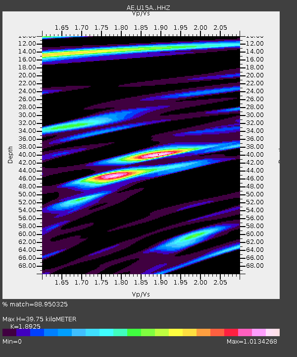
| Estimated Moho Depth: |
39.75 km |
| Estimated Crust Vp/Vs: |
1.89 |
| Assumed Crust Vp: |
6.194 km/s |
| Estimated Crust Vs: |
3.273 km/s |
| Estimated Crust Poisson's Ratio: |
0.31 |
|
| Radial Match: |
88.950325 % |
| Radial Bump: |
400 |
| Transverse Match: |
77.24664 % |
| Transverse Bump: |
400 |
| SOD ConfigId: |
11737051 |
| Insert Time: |
2019-04-25 15:04:41.267 +0000 |
| GWidth: |
2.5 |
| Max Bumps: |
400 |
| Tol: |
0.001 |
|

Signal To Noise
| Channel | StoN | STA | LTA |
| AE:U15A: :HHZ:20160924T21:18:33.01001Z | 2.7927752 | 2.7091357E-7 | 9.7005156E-8 |
| AE:U15A: :HHN:20160924T21:18:33.01001Z | 0.74406886 | 8.833831E-8 | 1.187233E-7 |
| AE:U15A: :HHE:20160924T21:18:33.01001Z | 0.9759694 | 8.8929326E-8 | 9.111897E-8 |
| Arrivals |
| Ps | 5.9 SECOND |
| PpPs | 18 SECOND |
| PsPs/PpSs | 24 SECOND |


