You are here: Home > Network List > US - United States National Seismic Network Stations List
> Station ELK Elko, Nevada, USA > Earthquake Result Viewer
ELK Elko, Nevada, USA - Earthquake Result Viewer
| Earthquake location: |
Solomon Islands |
| Earthquake latitude/longitude: |
-7.2/156.1 |
| Earthquake time(UTC): |
2007/04/02 (092) 04:11:39 GMT |
| Earthquake Depth: |
10 km |
| Earthquake Magnitude: |
5.6 MB, 5.3 MS |
| Earthquake Catalog/Contributor: |
WHDF/NEIC |
|
| Network: |
US United States National Seismic Network |
| Station: |
ELK Elko, Nevada, USA |
| Lat/Lon: |
40.74 N/115.24 W |
| Elevation: |
2210 m |
|
| Distance: |
93.7 deg |
| Az: |
49.565 deg |
| Baz: |
263.742 deg |
| Ray Param: |
0.041218467 |
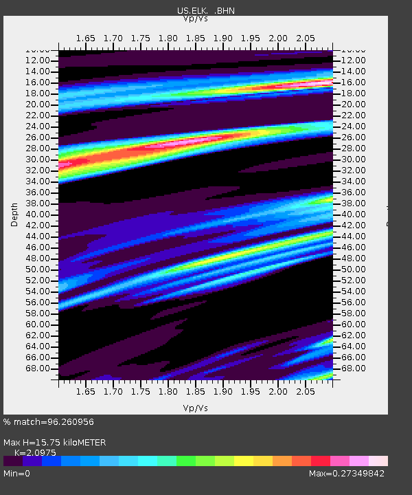
| Estimated Moho Depth: |
15.75 km |
| Estimated Crust Vp/Vs: |
2.10 |
| Assumed Crust Vp: |
6.276 km/s |
| Estimated Crust Vs: |
2.992 km/s |
| Estimated Crust Poisson's Ratio: |
0.35 |
|
| Radial Match: |
96.260956 % |
| Radial Bump: |
190 |
| Transverse Match: |
85.26993 % |
| Transverse Bump: |
294 |
| SOD ConfigId: |
2564 |
| Insert Time: |
2010-03-05 07:15:32.412 +0000 |
| GWidth: |
2.5 |
| Max Bumps: |
400 |
| Tol: |
0.001 |
|

Signal To Noise
| Channel | StoN | STA | LTA |
| US:ELK: :BHN:20070402T04:24:24.074004Z | 0.8580531 | 2.1802752E-8 | 2.540956E-8 |
| US:ELK: :BHE:20070402T04:24:24.074004Z | 0.88180655 | 1.9659646E-8 | 2.2294738E-8 |
| US:ELK: :BHZ:20070402T04:24:24.074004Z | 0.85688615 | 2.6167035E-8 | 3.0537354E-8 |
| Arrivals |
| Ps | 2.8 SECOND |
| PpPs | 7.6 SECOND |
| PsPs/PpSs | 10 SECOND |


