You are here: Home > Network List > AK - Alaska Regional Network Stations List
> Station TRF Thorofare Mountian, AK, USA > Earthquake Result Viewer
TRF Thorofare Mountian, AK, USA - Earthquake Result Viewer
| Earthquake location: |
Tonga Islands |
| Earthquake latitude/longitude: |
-18.1/-175.0 |
| Earthquake time(UTC): |
2016/09/24 (268) 21:07:13 GMT |
| Earthquake Depth: |
179 km |
| Earthquake Magnitude: |
6.3 MO |
| Earthquake Catalog/Contributor: |
NEIC PDE/NEIC ALERT |
|
| Network: |
AK Alaska Regional Network |
| Station: |
TRF Thorofare Mountian, AK, USA |
| Lat/Lon: |
63.45 N/150.29 W |
| Elevation: |
1710 m |
|
| Distance: |
83.5 deg |
| Az: |
10.9 deg |
| Baz: |
203.592 deg |
| Ray Param: |
0.04569136 |
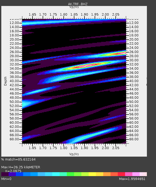
| Estimated Moho Depth: |
26.25 km |
| Estimated Crust Vp/Vs: |
2.10 |
| Assumed Crust Vp: |
6.438 km/s |
| Estimated Crust Vs: |
3.069 km/s |
| Estimated Crust Poisson's Ratio: |
0.35 |
|
| Radial Match: |
85.632164 % |
| Radial Bump: |
324 |
| Transverse Match: |
76.686356 % |
| Transverse Bump: |
326 |
| SOD ConfigId: |
11737051 |
| Insert Time: |
2019-04-25 15:05:28.590 +0000 |
| GWidth: |
2.5 |
| Max Bumps: |
400 |
| Tol: |
0.001 |
|

Signal To Noise
| Channel | StoN | STA | LTA |
| AK:TRF: :BHZ:20160924T21:18:50.187988Z | 7.4352083 | 5.8957943E-7 | 7.929561E-8 |
| AK:TRF: :BHN:20160924T21:18:50.187988Z | 1.5321919 | 2.0736276E-7 | 1.3533734E-7 |
| AK:TRF: :BHE:20160924T21:18:50.187988Z | 1.2983754 | 2.0745982E-7 | 1.5978416E-7 |
| Arrivals |
| Ps | 4.6 SECOND |
| PpPs | 12 SECOND |
| PsPs/PpSs | 17 SECOND |


