You are here: Home > Network List > BK - Berkeley Digital Seismograph Network Stations List
> Station HUMO Hull Mountain, OR > Earthquake Result Viewer
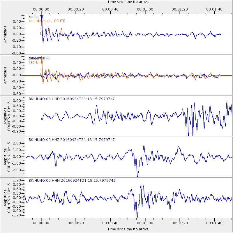
HUMO Hull Mountain, OR - Earthquake Result Viewer
*The percent match for this event was below the threshold and hence no stack was calculated.
| Earthquake location: |
Tonga Islands |
| Earthquake latitude/longitude: |
-18.1/-175.0 |
| Earthquake time(UTC): |
2016/09/24 (268) 21:07:13 GMT |
| Earthquake Depth: |
179 km |
| Earthquake Magnitude: |
6.3 MO |
| Earthquake Catalog/Contributor: |
NEIC PDE/NEIC ALERT |
|
| Network: |
BK Berkeley Digital Seismograph Network |
| Station: |
HUMO Hull Mountain, OR |
| Lat/Lon: |
42.61 N/122.96 W |
| Elevation: |
555 m |
|
| Distance: |
77.1 deg |
| Az: |
36.675 deg |
| Baz: |
230.309 deg |
| Ray Param: |
$rayparam |
*The percent match for this event was below the threshold and hence was not used in the summary stack. |
|
| Radial Match: |
76.09805 % |
| Radial Bump: |
400 |
| Transverse Match: |
62.567356 % |
| Transverse Bump: |
400 |
| SOD ConfigId: |
11737051 |
| Insert Time: |
2019-04-25 15:06:44.877 +0000 |
| GWidth: |
2.5 |
| Max Bumps: |
400 |
| Tol: |
0.001 |
|
Signal To Noise
| Channel | StoN | STA | LTA |
| BK:HUMO:00:HHZ:20160924T21:18:15.797974Z | 1.4188462 | 2.3215084E-7 | 1.6361945E-7 |
| BK:HUMO:00:HHN:20160924T21:18:15.797974Z | 1.0901978 | 1.9336066E-7 | 1.773629E-7 |
| BK:HUMO:00:HHE:20160924T21:18:15.797974Z | 2.64044 | 3.1386313E-7 | 1.1886774E-7 |
| Arrivals |
| Ps | |
| PpPs | |
| PsPs/PpSs | |


