You are here: Home > Network List > TA - USArray Transportable Network (new EarthScope stations) Stations List
> Station N16K Nishlik Lake, AK, USA > Earthquake Result Viewer
N16K Nishlik Lake, AK, USA - Earthquake Result Viewer
| Earthquake location: |
Tonga Islands |
| Earthquake latitude/longitude: |
-18.1/-175.0 |
| Earthquake time(UTC): |
2016/09/24 (268) 21:07:13 GMT |
| Earthquake Depth: |
179 km |
| Earthquake Magnitude: |
6.3 MO |
| Earthquake Catalog/Contributor: |
NEIC PDE/NEIC ALERT |
|
| Network: |
TA USArray Transportable Network (new EarthScope stations) |
| Station: |
N16K Nishlik Lake, AK, USA |
| Lat/Lon: |
60.47 N/158.77 W |
| Elevation: |
582 m |
|
| Distance: |
79.4 deg |
| Az: |
8.099 deg |
| Baz: |
195.697 deg |
| Ray Param: |
0.048554063 |
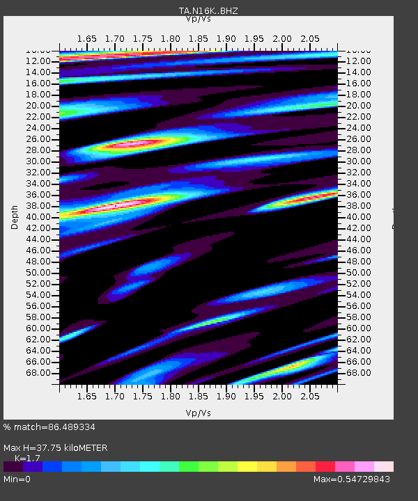
| Estimated Moho Depth: |
37.75 km |
| Estimated Crust Vp/Vs: |
1.70 |
| Assumed Crust Vp: |
6.276 km/s |
| Estimated Crust Vs: |
3.692 km/s |
| Estimated Crust Poisson's Ratio: |
0.24 |
|
| Radial Match: |
86.489334 % |
| Radial Bump: |
400 |
| Transverse Match: |
66.80595 % |
| Transverse Bump: |
400 |
| SOD ConfigId: |
11737051 |
| Insert Time: |
2019-04-25 15:11:58.027 +0000 |
| GWidth: |
2.5 |
| Max Bumps: |
400 |
| Tol: |
0.001 |
|

Signal To Noise
| Channel | StoN | STA | LTA |
| TA:N16K: :BHZ:20160924T21:18:28.549988Z | 3.4855084 | 2.6551106E-7 | 7.617571E-8 |
| TA:N16K: :BHN:20160924T21:18:28.549988Z | 1.2026672 | 1.0414517E-7 | 8.659517E-8 |
| TA:N16K: :BHE:20160924T21:18:28.549988Z | 1.5268891 | 1.1682899E-7 | 7.65144E-8 |
| Arrivals |
| Ps | 4.3 SECOND |
| PpPs | 16 SECOND |
| PsPs/PpSs | 20 SECOND |


