You are here: Home > Network List > TA - USArray Transportable Network (new EarthScope stations) Stations List
> Station N20K Mount Spurr, AK, USA > Earthquake Result Viewer
N20K Mount Spurr, AK, USA - Earthquake Result Viewer
| Earthquake location: |
Tonga Islands |
| Earthquake latitude/longitude: |
-18.1/-175.0 |
| Earthquake time(UTC): |
2016/09/24 (268) 21:07:13 GMT |
| Earthquake Depth: |
179 km |
| Earthquake Magnitude: |
6.3 MO |
| Earthquake Catalog/Contributor: |
NEIC PDE/NEIC ALERT |
|
| Network: |
TA USArray Transportable Network (new EarthScope stations) |
| Station: |
N20K Mount Spurr, AK, USA |
| Lat/Lon: |
61.20 N/152.21 W |
| Elevation: |
991 m |
|
| Distance: |
81.1 deg |
| Az: |
10.946 deg |
| Baz: |
201.9 deg |
| Ray Param: |
0.047376156 |
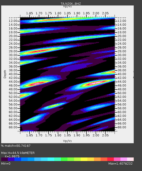
| Estimated Moho Depth: |
44.5 km |
| Estimated Crust Vp/Vs: |
2.00 |
| Assumed Crust Vp: |
6.566 km/s |
| Estimated Crust Vs: |
3.287 km/s |
| Estimated Crust Poisson's Ratio: |
0.33 |
|
| Radial Match: |
80.74167 % |
| Radial Bump: |
400 |
| Transverse Match: |
78.386246 % |
| Transverse Bump: |
400 |
| SOD ConfigId: |
11737051 |
| Insert Time: |
2019-04-25 15:12:00.335 +0000 |
| GWidth: |
2.5 |
| Max Bumps: |
400 |
| Tol: |
0.001 |
|

Signal To Noise
| Channel | StoN | STA | LTA |
| TA:N20K: :BHZ:20160924T21:18:37.674988Z | 3.7699642 | 3.8796617E-7 | 1.0290977E-7 |
| TA:N20K: :BHN:20160924T21:18:37.674988Z | 2.1712115 | 2.3414394E-7 | 1.0784023E-7 |
| TA:N20K: :BHE:20160924T21:18:37.674988Z | 1.4604365 | 1.6504913E-7 | 1.1301356E-7 |
| Arrivals |
| Ps | 6.9 SECOND |
| PpPs | 20 SECOND |
| PsPs/PpSs | 27 SECOND |


