You are here: Home > Network List > TA - USArray Transportable Network (new EarthScope stations) Stations List
> Station P17K Kvichak River, AK, USA > Earthquake Result Viewer
P17K Kvichak River, AK, USA - Earthquake Result Viewer

| Earthquake location: |
Tonga Islands |
| Earthquake latitude/longitude: |
-18.1/-175.0 |
| Earthquake time(UTC): |
2016/09/24 (268) 21:07:13 GMT |
| Earthquake Depth: |
179 km |
| Earthquake Magnitude: |
6.3 MO |
| Earthquake Catalog/Contributor: |
NEIC PDE/NEIC ALERT |
|
| Network: |
TA USArray Transportable Network (new EarthScope stations) |
| Station: |
P17K Kvichak River, AK, USA |
| Lat/Lon: |
59.20 N/156.44 W |
| Elevation: |
91 m |
|
| Distance: |
78.5 deg |
| Az: |
9.625 deg |
| Baz: |
198.0 deg |
| Ray Param: |
0.049155146 |
| Estimated Moho Depth: |
54.0 km |
| Estimated Crust Vp/Vs: |
1.60 |
| Assumed Crust Vp: |
6.276 km/s |
| Estimated Crust Vs: |
3.922 km/s |
| Estimated Crust Poisson's Ratio: |
0.18 |
|
| Radial Match: |
83.16906 % |
| Radial Bump: |
400 |
| Transverse Match: |
79.58082 % |
| Transverse Bump: |
400 |
| SOD ConfigId: |
11737051 |
| Insert Time: |
2019-04-25 15:12:10.167 +0000 |
| GWidth: |
2.5 |
| Max Bumps: |
400 |
| Tol: |
0.001 |
|
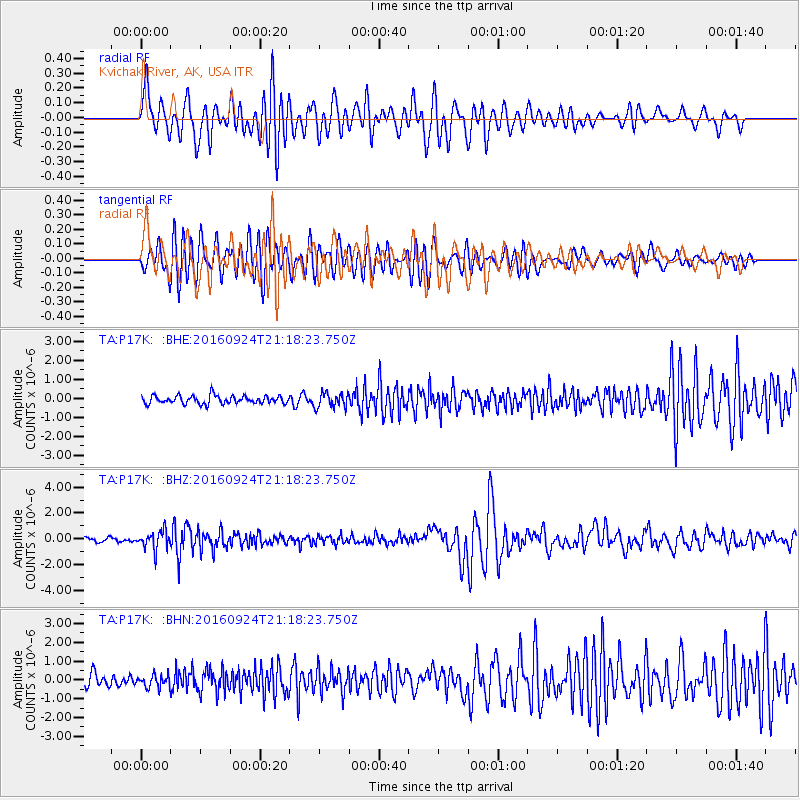
Signal To Noise
| Channel | StoN | STA | LTA |
| TA:P17K: :BHZ:20160924T21:18:23.750Z | 4.156074 | 7.2878225E-7 | 1.7535353E-7 |
| TA:P17K: :BHN:20160924T21:18:23.750Z | 1.2663637 | 3.3752863E-7 | 2.665337E-7 |
| TA:P17K: :BHE:20160924T21:18:23.750Z | 1.7524517 | 3.730967E-7 | 2.1289983E-7 |
| Arrivals |
| Ps | 5.3 SECOND |
| PpPs | 22 SECOND |
| PsPs/PpSs | 27 SECOND |


