You are here: Home > Network List > TA - USArray Transportable Network (new EarthScope stations) Stations List
> Station R33M Jennings River, BC, CAN > Earthquake Result Viewer
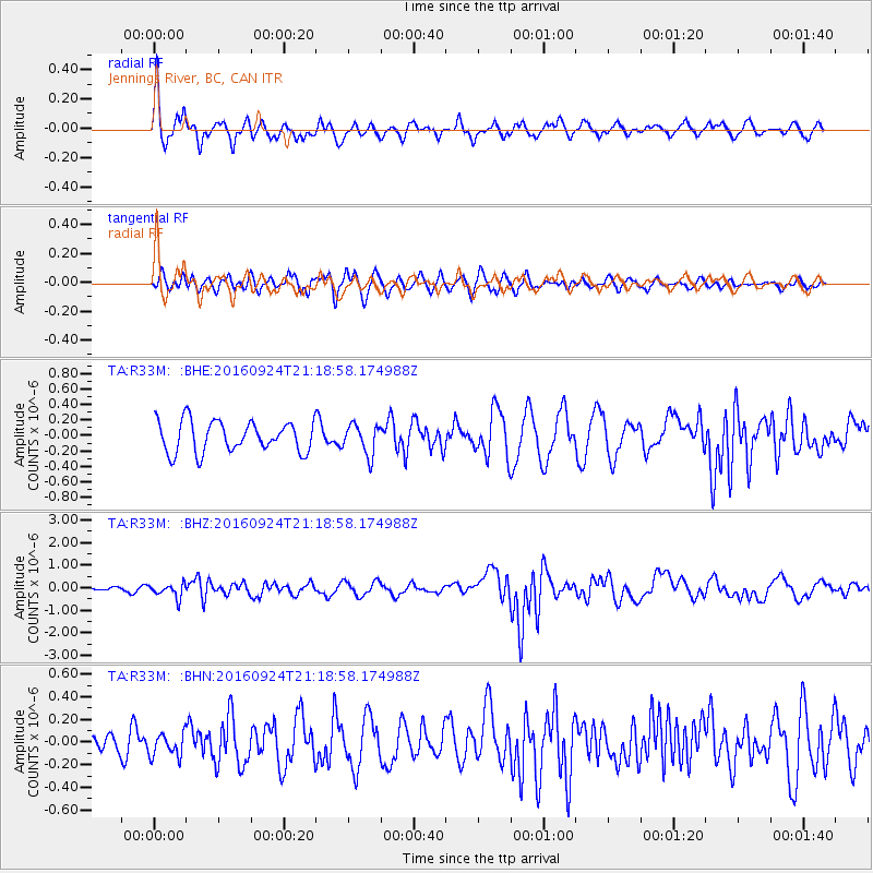
R33M Jennings River, BC, CAN - Earthquake Result Viewer
*The percent match for this event was below the threshold and hence no stack was calculated.
| Earthquake location: |
Tonga Islands |
| Earthquake latitude/longitude: |
-18.1/-175.0 |
| Earthquake time(UTC): |
2016/09/24 (268) 21:07:13 GMT |
| Earthquake Depth: |
179 km |
| Earthquake Magnitude: |
6.3 MO |
| Earthquake Catalog/Contributor: |
NEIC PDE/NEIC ALERT |
|
| Network: |
TA USArray Transportable Network (new EarthScope stations) |
| Station: |
R33M Jennings River, BC, CAN |
| Lat/Lon: |
59.39 N/130.97 W |
| Elevation: |
1437 m |
|
| Distance: |
85.1 deg |
| Az: |
20.913 deg |
| Baz: |
221.571 deg |
| Ray Param: |
$rayparam |
*The percent match for this event was below the threshold and hence was not used in the summary stack. |
|
| Radial Match: |
63.2834 % |
| Radial Bump: |
382 |
| Transverse Match: |
60.173706 % |
| Transverse Bump: |
400 |
| SOD ConfigId: |
11737051 |
| Insert Time: |
2019-04-25 15:12:16.865 +0000 |
| GWidth: |
2.5 |
| Max Bumps: |
400 |
| Tol: |
0.001 |
|
Signal To Noise
| Channel | StoN | STA | LTA |
| TA:R33M: :BHZ:20160924T21:18:58.174988Z | 2.935608 | 3.0390382E-7 | 1.035233E-7 |
| TA:R33M: :BHN:20160924T21:18:58.174988Z | 0.9852261 | 1.0459514E-7 | 1.0616358E-7 |
| TA:R33M: :BHE:20160924T21:18:58.174988Z | 0.99110687 | 1.9529227E-7 | 1.9704461E-7 |
| Arrivals |
| Ps | |
| PpPs | |
| PsPs/PpSs | |


