You are here: Home > Network List > GS - US Geological Survey Networks Stations List
> Station KAN06 West of Argonia, Argonia, KS, USA > Earthquake Result Viewer
KAN06 West of Argonia, Argonia, KS, USA - Earthquake Result Viewer
| Earthquake location: |
Near Coast Of Central Chile |
| Earthquake latitude/longitude: |
-30.8/-71.4 |
| Earthquake time(UTC): |
2015/09/26 (269) 02:51:18 GMT |
| Earthquake Depth: |
38 km |
| Earthquake Magnitude: |
6.2 MO |
| Earthquake Catalog/Contributor: |
NEIC PDE/NEIC ALERT |
|
| Network: |
GS US Geological Survey Networks |
| Station: |
KAN06 West of Argonia, Argonia, KS, USA |
| Lat/Lon: |
37.25 N/97.86 W |
| Elevation: |
393 m |
|
| Distance: |
72.1 deg |
| Az: |
338.05 deg |
| Baz: |
156.235 deg |
| Ray Param: |
0.053819034 |
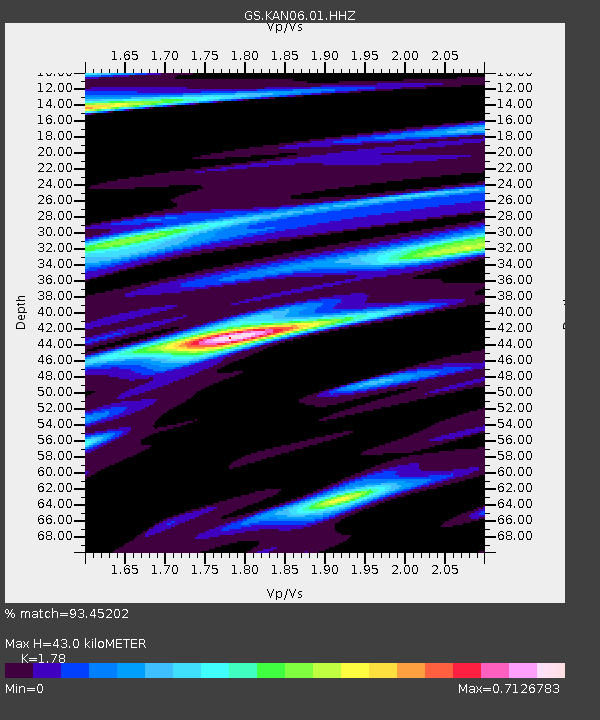
| Estimated Moho Depth: |
43.0 km |
| Estimated Crust Vp/Vs: |
1.78 |
| Assumed Crust Vp: |
6.483 km/s |
| Estimated Crust Vs: |
3.642 km/s |
| Estimated Crust Poisson's Ratio: |
0.27 |
|
| Radial Match: |
93.45202 % |
| Radial Bump: |
315 |
| Transverse Match: |
24.649624 % |
| Transverse Bump: |
400 |
| SOD ConfigId: |
1156111 |
| Insert Time: |
2015-10-10 03:24:53.148 +0000 |
| GWidth: |
2.5 |
| Max Bumps: |
400 |
| Tol: |
0.001 |
|

Signal To Noise
| Channel | StoN | STA | LTA |
| GS:KAN06:01:HHZ:20150926T03:02:07.754993Z | 24.63783 | 5.0792482E-6 | 2.0615647E-7 |
| GS:KAN06:01:HHN:20150926T03:02:07.754993Z | 7.00432 | 2.4359829E-6 | 3.4778293E-7 |
| GS:KAN06:01:HHE:20150926T03:02:07.754993Z | 3.1065292 | 1.1273545E-6 | 3.6289842E-7 |
| Arrivals |
| Ps | 5.4 SECOND |
| PpPs | 18 SECOND |
| PsPs/PpSs | 23 SECOND |


