You are here: Home > Network List > GS - US Geological Survey Networks Stations List
> Station KAN16 SW of Harper, Kansas - Bergman residence > Earthquake Result Viewer
KAN16 SW of Harper, Kansas - Bergman residence - Earthquake Result Viewer
| Earthquake location: |
Near Coast Of Central Chile |
| Earthquake latitude/longitude: |
-30.8/-71.4 |
| Earthquake time(UTC): |
2015/09/26 (269) 02:51:18 GMT |
| Earthquake Depth: |
38 km |
| Earthquake Magnitude: |
6.2 MO |
| Earthquake Catalog/Contributor: |
NEIC PDE/NEIC ALERT |
|
| Network: |
GS US Geological Survey Networks |
| Station: |
KAN16 SW of Harper, Kansas - Bergman residence |
| Lat/Lon: |
37.23 N/98.06 W |
| Elevation: |
435 m |
|
| Distance: |
72.2 deg |
| Az: |
337.882 deg |
| Baz: |
156.059 deg |
| Ray Param: |
0.053788267 |
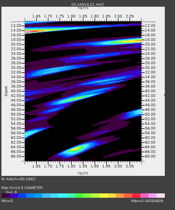
| Estimated Moho Depth: |
14.5 km |
| Estimated Crust Vp/Vs: |
1.60 |
| Assumed Crust Vp: |
6.426 km/s |
| Estimated Crust Vs: |
4.016 km/s |
| Estimated Crust Poisson's Ratio: |
0.18 |
|
| Radial Match: |
90.0683 % |
| Radial Bump: |
345 |
| Transverse Match: |
49.82203 % |
| Transverse Bump: |
400 |
| SOD ConfigId: |
1156111 |
| Insert Time: |
2015-10-10 03:25:48.077 +0000 |
| GWidth: |
2.5 |
| Max Bumps: |
400 |
| Tol: |
0.001 |
|

Signal To Noise
| Channel | StoN | STA | LTA |
| GS:KAN16:01:HHZ:20150926T03:02:08.030017Z | 29.309284 | 5.060269E-6 | 1.7265072E-7 |
| GS:KAN16:01:HHN:20150926T03:02:08.030017Z | 6.5384417 | 1.7406526E-6 | 2.6621825E-7 |
| GS:KAN16:01:HHE:20150926T03:02:08.030017Z | 1.7403916 | 1.9193724E-6 | 1.1028394E-6 |
| Arrivals |
| Ps | 1.4 SECOND |
| PpPs | 5.6 SECOND |
| PsPs/PpSs | 7.1 SECOND |


