You are here: Home > Network List > C1 - Red Sismologica Nacional Stations List
> Station MT09 Talagante > Earthquake Result Viewer
MT09 Talagante - Earthquake Result Viewer
| Earthquake location: |
Fiji Islands Region |
| Earthquake latitude/longitude: |
-19.8/-178.3 |
| Earthquake time(UTC): |
2016/09/24 (268) 21:28:42 GMT |
| Earthquake Depth: |
594 km |
| Earthquake Magnitude: |
6.8 MO |
| Earthquake Catalog/Contributor: |
NEIC PDE/NEIC ALERT |
|
| Network: |
C1 Red Sismologica Nacional |
| Station: |
MT09 Talagante |
| Lat/Lon: |
33.78 S/70.99 W |
| Elevation: |
1371 m |
|
| Distance: |
92.7 deg |
| Az: |
127.233 deg |
| Baz: |
244.138 deg |
| Ray Param: |
0.04092357 |
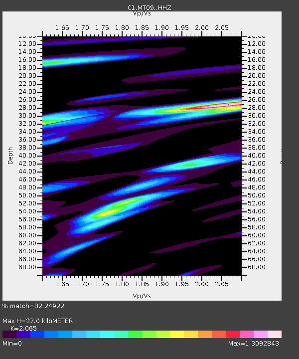
| Estimated Moho Depth: |
27.0 km |
| Estimated Crust Vp/Vs: |
2.07 |
| Assumed Crust Vp: |
6.481 km/s |
| Estimated Crust Vs: |
3.138 km/s |
| Estimated Crust Poisson's Ratio: |
0.35 |
|
| Radial Match: |
82.24922 % |
| Radial Bump: |
400 |
| Transverse Match: |
77.85676 % |
| Transverse Bump: |
400 |
| SOD ConfigId: |
11737051 |
| Insert Time: |
2019-04-25 15:18:20.980 +0000 |
| GWidth: |
2.5 |
| Max Bumps: |
400 |
| Tol: |
0.001 |
|

Signal To Noise
| Channel | StoN | STA | LTA |
| C1:MT09: :HHZ:20160924T21:40:19.478027Z | 3.4451919 | 1.7316438E-6 | 5.026262E-7 |
| C1:MT09: :HHN:20160924T21:40:19.478027Z | 1.4269458 | 4.293779E-7 | 3.0090695E-7 |
| C1:MT09: :HHE:20160924T21:40:19.478027Z | 0.92775863 | 4.3261167E-7 | 4.6629765E-7 |
| Arrivals |
| Ps | 4.5 SECOND |
| PpPs | 13 SECOND |
| PsPs/PpSs | 17 SECOND |


