You are here: Home > Network List > CN - Canadian National Seismograph Network Stations List
> Station PNT Penticton, BC, CA > Earthquake Result Viewer
PNT Penticton, BC, CA - Earthquake Result Viewer
| Earthquake location: |
Fiji Islands Region |
| Earthquake latitude/longitude: |
-19.8/-178.3 |
| Earthquake time(UTC): |
2016/09/24 (268) 21:28:42 GMT |
| Earthquake Depth: |
594 km |
| Earthquake Magnitude: |
6.8 MO |
| Earthquake Catalog/Contributor: |
NEIC PDE/NEIC ALERT |
|
| Network: |
CN Canadian National Seismograph Network |
| Station: |
PNT Penticton, BC, CA |
| Lat/Lon: |
49.32 N/119.63 W |
| Elevation: |
531 m |
|
| Distance: |
86.2 deg |
| Az: |
34.053 deg |
| Baz: |
233.67 deg |
| Ray Param: |
0.042461615 |
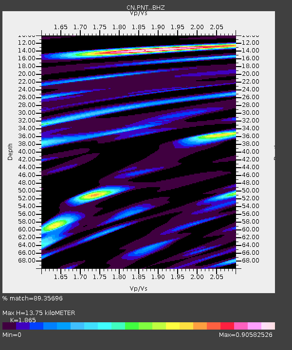
| Estimated Moho Depth: |
13.75 km |
| Estimated Crust Vp/Vs: |
1.87 |
| Assumed Crust Vp: |
6.419 km/s |
| Estimated Crust Vs: |
3.442 km/s |
| Estimated Crust Poisson's Ratio: |
0.30 |
|
| Radial Match: |
89.35696 % |
| Radial Bump: |
400 |
| Transverse Match: |
85.98933 % |
| Transverse Bump: |
400 |
| SOD ConfigId: |
11737051 |
| Insert Time: |
2019-04-25 15:19:52.266 +0000 |
| GWidth: |
2.5 |
| Max Bumps: |
400 |
| Tol: |
0.001 |
|

Signal To Noise
| Channel | StoN | STA | LTA |
| CN:PNT: :BHZ:20160924T21:39:49.625Z | 19.629967 | 2.6306723E-6 | 1.3401308E-7 |
| CN:PNT: :BHN:20160924T21:39:49.625Z | 4.580086 | 6.267053E-7 | 1.3683264E-7 |
| CN:PNT: :BHE:20160924T21:39:49.625Z | 7.6325026 | 1.0162024E-6 | 1.3314144E-7 |
| Arrivals |
| Ps | 1.9 SECOND |
| PpPs | 6.0 SECOND |
| PsPs/PpSs | 7.9 SECOND |


