You are here: Home > Network List > US - United States National Seismic Network Stations List
> Station ELK Elko, Nevada, USA > Earthquake Result Viewer
ELK Elko, Nevada, USA - Earthquake Result Viewer
| Earthquake location: |
Near Coast Of Peru |
| Earthquake latitude/longitude: |
-17.7/-71.6 |
| Earthquake time(UTC): |
2001/06/26 (177) 04:18:31 GMT |
| Earthquake Depth: |
24 km |
| Earthquake Magnitude: |
6.2 MB, 6.7 MS, 6.8 MW, 6.7 ME |
| Earthquake Catalog/Contributor: |
WHDF/NEIC |
|
| Network: |
US United States National Seismic Network |
| Station: |
ELK Elko, Nevada, USA |
| Lat/Lon: |
40.74 N/115.24 W |
| Elevation: |
2210 m |
|
| Distance: |
70.9 deg |
| Az: |
326.328 deg |
| Baz: |
135.937 deg |
| Ray Param: |
0.05465867 |
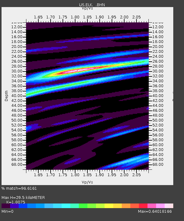
| Estimated Moho Depth: |
29.5 km |
| Estimated Crust Vp/Vs: |
1.81 |
| Assumed Crust Vp: |
6.276 km/s |
| Estimated Crust Vs: |
3.472 km/s |
| Estimated Crust Poisson's Ratio: |
0.28 |
|
| Radial Match: |
96.6161 % |
| Radial Bump: |
365 |
| Transverse Match: |
89.32331 % |
| Transverse Bump: |
400 |
| SOD ConfigId: |
110165 |
| Insert Time: |
2010-03-05 07:18:46.548 +0000 |
| GWidth: |
2.5 |
| Max Bumps: |
400 |
| Tol: |
0.001 |
|

Signal To Noise
| Channel | StoN | STA | LTA |
| US:ELK: :BHN:20010626T04:29:15.14001Z | 1.2545007 | 4.4200252E-8 | 3.5233338E-8 |
| US:ELK: :BHE:20010626T04:29:15.14001Z | 1.4036502 | 4.48974E-8 | 3.1986175E-8 |
| US:ELK: :BHZ:20010626T04:29:15.14001Z | 1.8084897 | 9.424622E-8 | 5.211322E-8 |
| Arrivals |
| Ps | 3.9 SECOND |
| PpPs | 13 SECOND |
| PsPs/PpSs | 17 SECOND |


