You are here: Home > Network List > US - United States National Seismic Network Stations List
> Station ELK Elko, Nevada, USA > Earthquake Result Viewer
ELK Elko, Nevada, USA - Earthquake Result Viewer
| Earthquake location: |
East Of North Island, N.Z. |
| Earthquake latitude/longitude: |
-36.8/-179.6 |
| Earthquake time(UTC): |
2001/08/21 (233) 06:52:06 GMT |
| Earthquake Depth: |
33 km |
| Earthquake Magnitude: |
6.4 MB, 7.1 MS, 7.2 ME, 7.0 ML |
| Earthquake Catalog/Contributor: |
WHDF/NEIC |
|
| Network: |
US United States National Seismic Network |
| Station: |
ELK Elko, Nevada, USA |
| Lat/Lon: |
40.74 N/115.24 W |
| Elevation: |
2210 m |
|
| Distance: |
97.1 deg |
| Az: |
43.642 deg |
| Baz: |
226.8 deg |
| Ray Param: |
0.0402959 |
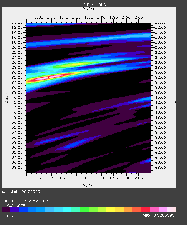
| Estimated Moho Depth: |
31.75 km |
| Estimated Crust Vp/Vs: |
1.69 |
| Assumed Crust Vp: |
6.276 km/s |
| Estimated Crust Vs: |
3.719 km/s |
| Estimated Crust Poisson's Ratio: |
0.23 |
|
| Radial Match: |
98.27989 % |
| Radial Bump: |
341 |
| Transverse Match: |
88.72295 % |
| Transverse Bump: |
400 |
| SOD ConfigId: |
110177 |
| Insert Time: |
2010-03-05 07:18:57.777 +0000 |
| GWidth: |
2.5 |
| Max Bumps: |
400 |
| Tol: |
0.001 |
|
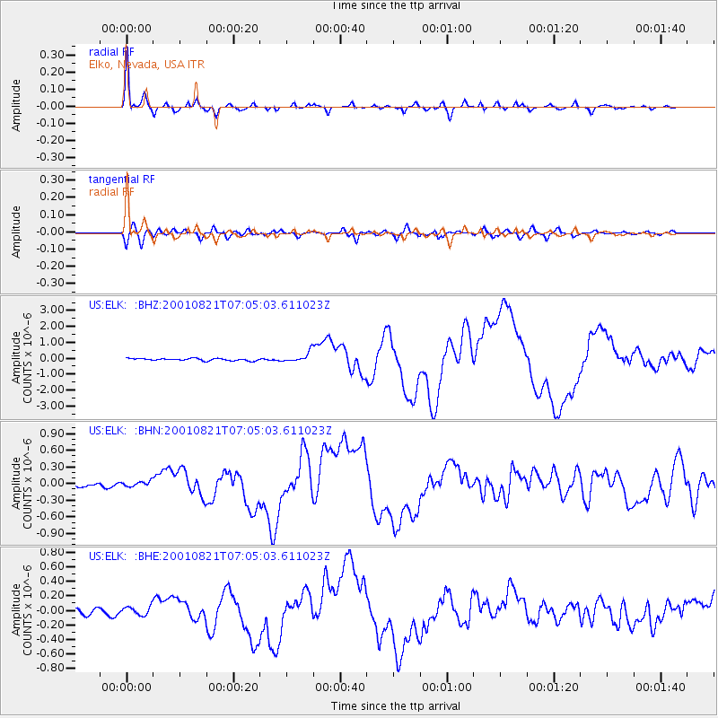
Signal To Noise
| Channel | StoN | STA | LTA |
| US:ELK: :BHN:20010821T07:05:03.611023Z | 0.98194104 | 4.792484E-8 | 4.8806232E-8 |
| US:ELK: :BHE:20010821T07:05:03.611023Z | 1.7183725 | 6.045793E-8 | 3.518325E-8 |
| US:ELK: :BHZ:20010821T07:05:03.611023Z | 4.8299046 | 3.2029897E-7 | 6.631579E-8 |
| Arrivals |
| Ps | 3.5 SECOND |
| PpPs | 13 SECOND |
| PsPs/PpSs | 17 SECOND |


