You are here: Home > Network List > TA - USArray Transportable Network (new EarthScope stations) Stations List
> Station 109C Camp Elliot, Mirimar, CA, USA > Earthquake Result Viewer
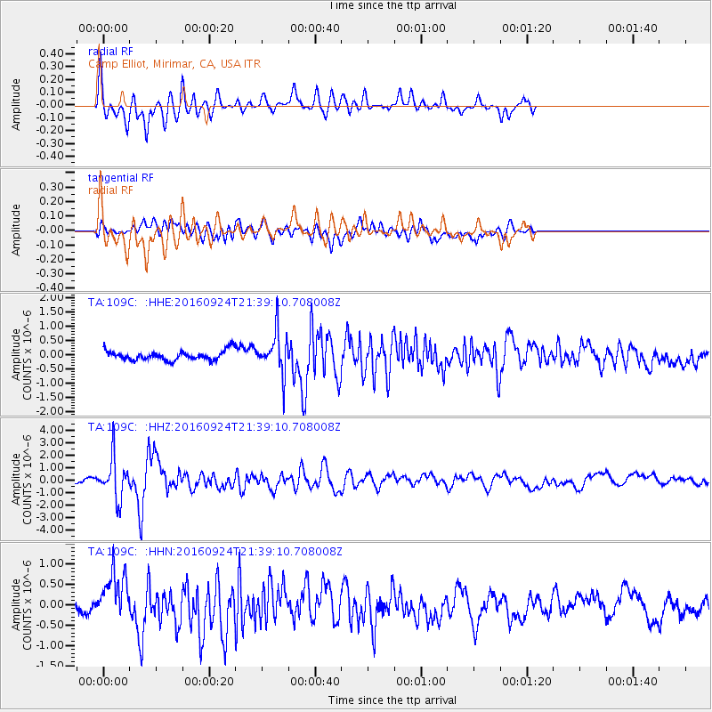
109C Camp Elliot, Mirimar, CA, USA - Earthquake Result Viewer
*The percent match for this event was below the threshold and hence no stack was calculated.
| Earthquake location: |
Fiji Islands Region |
| Earthquake latitude/longitude: |
-19.8/-178.3 |
| Earthquake time(UTC): |
2016/09/24 (268) 21:28:42 GMT |
| Earthquake Depth: |
594 km |
| Earthquake Magnitude: |
6.8 MO |
| Earthquake Catalog/Contributor: |
NEIC PDE/NEIC ALERT |
|
| Network: |
TA USArray Transportable Network (new EarthScope stations) |
| Station: |
109C Camp Elliot, Mirimar, CA, USA |
| Lat/Lon: |
32.89 N/117.11 W |
| Elevation: |
150 m |
|
| Distance: |
78.5 deg |
| Az: |
48.782 deg |
| Baz: |
237.311 deg |
| Ray Param: |
$rayparam |
*The percent match for this event was below the threshold and hence was not used in the summary stack. |
|
| Radial Match: |
75.03529 % |
| Radial Bump: |
400 |
| Transverse Match: |
56.054913 % |
| Transverse Bump: |
400 |
| SOD ConfigId: |
11737051 |
| Insert Time: |
2019-04-25 15:23:07.900 +0000 |
| GWidth: |
2.5 |
| Max Bumps: |
400 |
| Tol: |
0.001 |
|
Signal To Noise
| Channel | StoN | STA | LTA |
| TA:109C: :HHZ:20160924T21:39:10.708008Z | 6.60086 | 1.6412953E-6 | 2.4864872E-7 |
| TA:109C: :HHN:20160924T21:39:10.708008Z | 1.9951242 | 5.9559085E-7 | 2.985232E-7 |
| TA:109C: :HHE:20160924T21:39:10.708008Z | 4.3860655 | 7.37993E-7 | 1.6825854E-7 |
| Arrivals |
| Ps | |
| PpPs | |
| PsPs/PpSs | |


