You are here: Home > Network List > TA - USArray Transportable Network (new EarthScope stations) Stations List
> Station F21K Alatna River, AK, USA > Earthquake Result Viewer
F21K Alatna River, AK, USA - Earthquake Result Viewer
| Earthquake location: |
Fiji Islands Region |
| Earthquake latitude/longitude: |
-19.8/-178.3 |
| Earthquake time(UTC): |
2016/09/24 (268) 21:28:42 GMT |
| Earthquake Depth: |
594 km |
| Earthquake Magnitude: |
6.8 MO |
| Earthquake Catalog/Contributor: |
NEIC PDE/NEIC ALERT |
|
| Network: |
TA USArray Transportable Network (new EarthScope stations) |
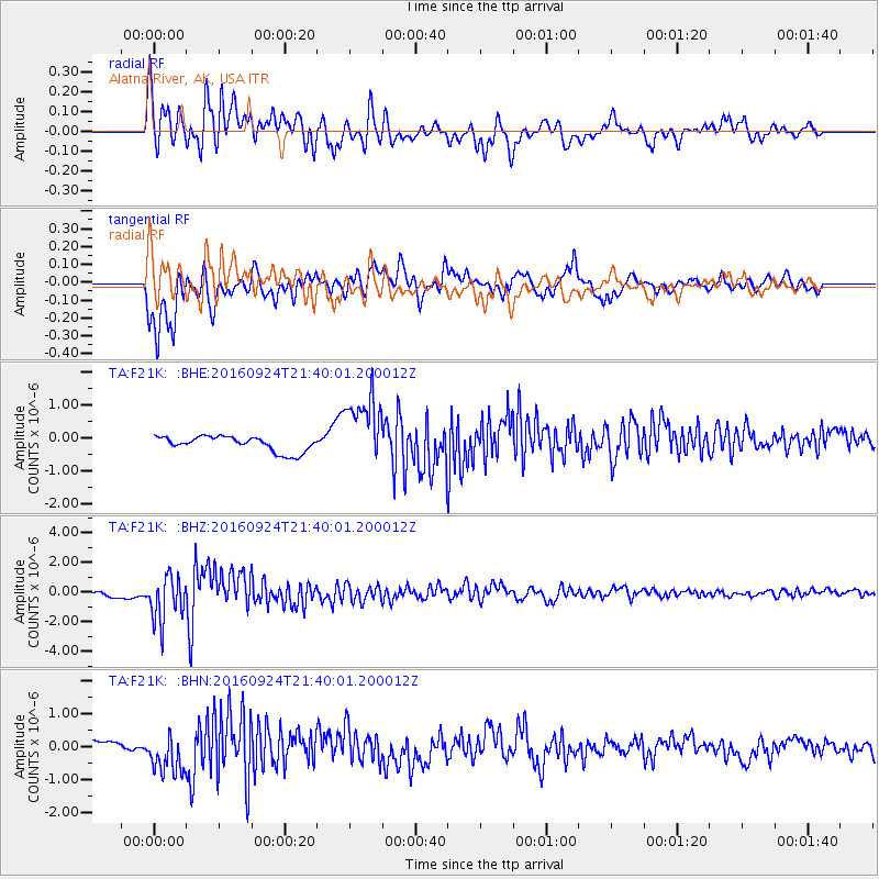
| Station: |
F21K Alatna River, AK, USA |
| Lat/Lon: |
67.22 N/153.48 W |
| Elevation: |
597 m |
|
| Distance: |
88.7 deg |
| Az: |
9.398 deg |
| Baz: |
203.251 deg |
| Ray Param: |
0.041630622 |
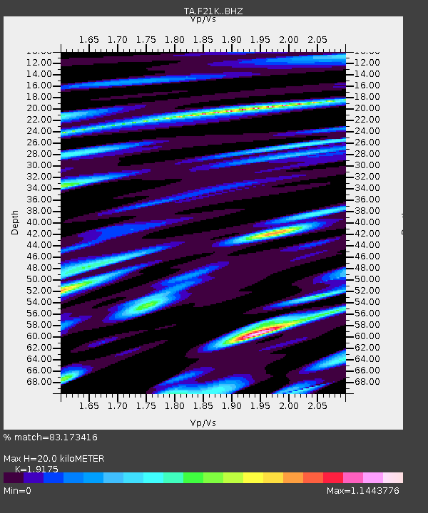
| Estimated Moho Depth: |
20.0 km |
| Estimated Crust Vp/Vs: |
1.92 |
| Assumed Crust Vp: |
6.455 km/s |
| Estimated Crust Vs: |
3.366 km/s |
| Estimated Crust Poisson's Ratio: |
0.31 |
|
| Radial Match: |
83.173416 % |
| Radial Bump: |
400 |
| Transverse Match: |
72.0905 % |
| Transverse Bump: |
400 |
| SOD ConfigId: |
11737051 |
| Insert Time: |
2019-04-25 15:23:21.102 +0000 |
| GWidth: |
2.5 |
| Max Bumps: |
400 |
| Tol: |
0.001 |
|
Signal To Noise
| Channel | StoN | STA | LTA |
| TA:F21K: :BHZ:20160924T21:40:01.200012Z | 10.323452 | 1.5465149E-6 | 1.4980598E-7 |
| TA:F21K: :BHN:20160924T21:40:01.200012Z | 3.8770664 | 6.444507E-7 | 1.6622123E-7 |
| TA:F21K: :BHE:20160924T21:40:01.200012Z | 4.5352006 | 1.0280818E-6 | 2.2668937E-7 |
| Arrivals |
| Ps | 2.9 SECOND |
| PpPs | 8.9 SECOND |
| PsPs/PpSs | 12 SECOND |


