You are here: Home > Network List > IW - Intermountain West Stations List
> Station MOOW Moose Ponds, Wyoming, USA > Earthquake Result Viewer
MOOW Moose Ponds, Wyoming, USA - Earthquake Result Viewer
| Earthquake location: |
Near Coast Of Central Chile |
| Earthquake latitude/longitude: |
-30.8/-71.4 |
| Earthquake time(UTC): |
2015/09/26 (269) 02:51:18 GMT |
| Earthquake Depth: |
38 km |
| Earthquake Magnitude: |
6.2 MO |
| Earthquake Catalog/Contributor: |
NEIC PDE/NEIC ALERT |
|
| Network: |
IW Intermountain West |
| Station: |
MOOW Moose Ponds, Wyoming, USA |
| Lat/Lon: |
43.75 N/110.74 W |
| Elevation: |
2128 m |
|
| Distance: |
82.5 deg |
| Az: |
332.382 deg |
| Baz: |
146.612 deg |
| Ray Param: |
0.046797715 |
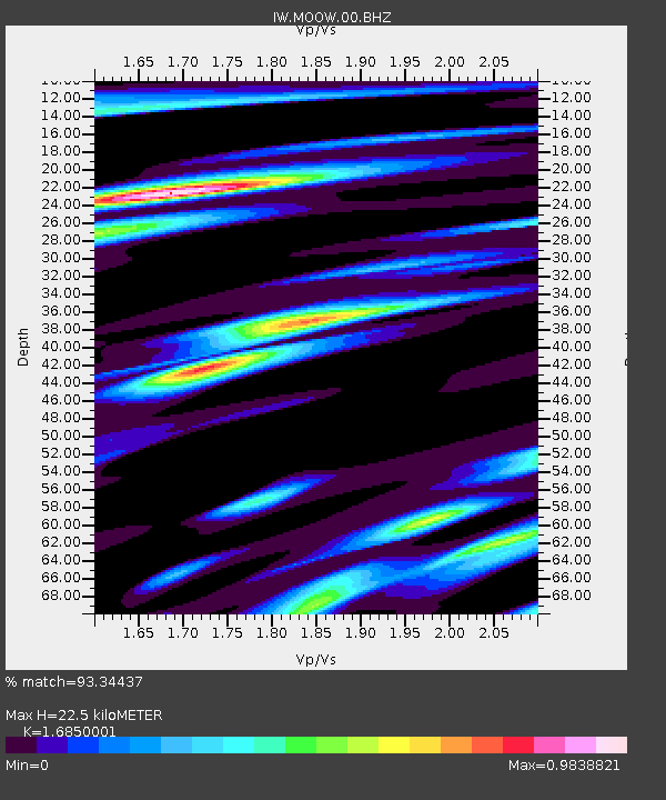
| Estimated Moho Depth: |
22.5 km |
| Estimated Crust Vp/Vs: |
1.69 |
| Assumed Crust Vp: |
6.207 km/s |
| Estimated Crust Vs: |
3.684 km/s |
| Estimated Crust Poisson's Ratio: |
0.23 |
|
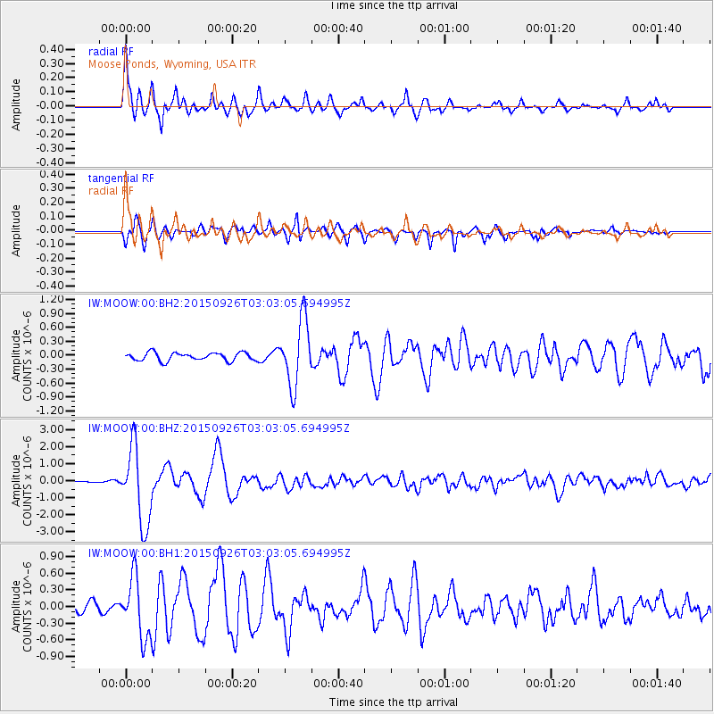
| Radial Match: |
93.34437 % |
| Radial Bump: |
400 |
| Transverse Match: |
86.16424 % |
| Transverse Bump: |
400 |
| SOD ConfigId: |
1156111 |
| Insert Time: |
2015-10-10 03:28:45.595 +0000 |
| GWidth: |
2.5 |
| Max Bumps: |
400 |
| Tol: |
0.001 |
|
Signal To Noise
| Channel | StoN | STA | LTA |
| IW:MOOW:00:BHZ:20150926T03:03:05.694995Z | 20.578688 | 2.2847923E-6 | 1.1102712E-7 |
| IW:MOOW:00:BH1:20150926T03:03:05.694995Z | 6.598912 | 5.433056E-7 | 8.23326E-8 |
| IW:MOOW:00:BH2:20150926T03:03:05.694995Z | 8.32798 | 7.175021E-7 | 8.6155595E-8 |
| Arrivals |
| Ps | 2.5 SECOND |
| PpPs | 9.5 SECOND |
| PsPs/PpSs | 12 SECOND |


