You are here: Home > Network List > TA - USArray Transportable Network (new EarthScope stations) Stations List
> Station K24K Donnelly Dome, AK, USA > Earthquake Result Viewer
K24K Donnelly Dome, AK, USA - Earthquake Result Viewer
| Earthquake location: |
Fiji Islands Region |
| Earthquake latitude/longitude: |
-19.8/-178.3 |
| Earthquake time(UTC): |
2016/09/24 (268) 21:28:42 GMT |
| Earthquake Depth: |
594 km |
| Earthquake Magnitude: |
6.8 MO |
| Earthquake Catalog/Contributor: |
NEIC PDE/NEIC ALERT |
|
| Network: |
TA USArray Transportable Network (new EarthScope stations) |
| Station: |
K24K Donnelly Dome, AK, USA |
| Lat/Lon: |
63.80 N/145.78 W |
| Elevation: |
724 m |
|
| Distance: |
87.1 deg |
| Az: |
13.811 deg |
| Baz: |
210.419 deg |
| Ray Param: |
0.041846797 |
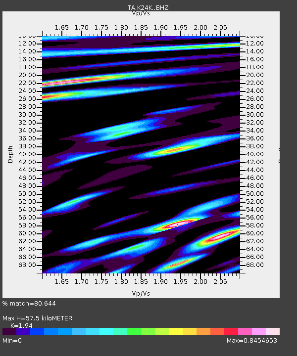
| Estimated Moho Depth: |
57.5 km |
| Estimated Crust Vp/Vs: |
1.94 |
| Assumed Crust Vp: |
6.566 km/s |
| Estimated Crust Vs: |
3.385 km/s |
| Estimated Crust Poisson's Ratio: |
0.32 |
|
| Radial Match: |
80.644 % |
| Radial Bump: |
400 |
| Transverse Match: |
72.13788 % |
| Transverse Bump: |
400 |
| SOD ConfigId: |
11737051 |
| Insert Time: |
2019-04-25 15:23:54.676 +0000 |
| GWidth: |
2.5 |
| Max Bumps: |
400 |
| Tol: |
0.001 |
|

Signal To Noise
| Channel | StoN | STA | LTA |
| TA:K24K: :BHZ:20160924T21:39:53.724976Z | 23.05394 | 5.003229E-6 | 2.1702273E-7 |
| TA:K24K: :BHN:20160924T21:39:53.724976Z | 4.84157 | 1.3850238E-6 | 2.8606917E-7 |
| TA:K24K: :BHE:20160924T21:39:53.724976Z | 1.4941311 | 8.3863193E-7 | 5.61284E-7 |
| Arrivals |
| Ps | 8.4 SECOND |
| PpPs | 25 SECOND |
| PsPs/PpSs | 34 SECOND |


