You are here: Home > Network List > TA - USArray Transportable Network (new EarthScope stations) Stations List
> Station M29M Somme Creek, YT, CAN > Earthquake Result Viewer
M29M Somme Creek, YT, CAN - Earthquake Result Viewer
| Earthquake location: |
Fiji Islands Region |
| Earthquake latitude/longitude: |
-19.8/-178.3 |
| Earthquake time(UTC): |
2016/09/24 (268) 21:28:42 GMT |
| Earthquake Depth: |
594 km |
| Earthquake Magnitude: |
6.8 MO |
| Earthquake Catalog/Contributor: |
NEIC PDE/NEIC ALERT |
|
| Network: |
TA USArray Transportable Network (new EarthScope stations) |
| Station: |
M29M Somme Creek, YT, CAN |
| Lat/Lon: |
62.44 N/138.46 W |
| Elevation: |
1297 m |
|
| Distance: |
87.8 deg |
| Az: |
17.335 deg |
| Baz: |
217.093 deg |
| Ray Param: |
0.041694187 |
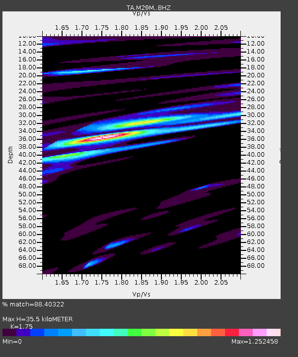
| Estimated Moho Depth: |
35.5 km |
| Estimated Crust Vp/Vs: |
1.75 |
| Assumed Crust Vp: |
6.566 km/s |
| Estimated Crust Vs: |
3.752 km/s |
| Estimated Crust Poisson's Ratio: |
0.26 |
|
| Radial Match: |
88.40322 % |
| Radial Bump: |
400 |
| Transverse Match: |
66.766495 % |
| Transverse Bump: |
400 |
| SOD ConfigId: |
11737051 |
| Insert Time: |
2019-04-25 15:24:09.621 +0000 |
| GWidth: |
2.5 |
| Max Bumps: |
400 |
| Tol: |
0.001 |
|

Signal To Noise
| Channel | StoN | STA | LTA |
| TA:M29M: :BHZ:20160924T21:39:57.049988Z | 13.855698 | 2.5271688E-6 | 1.8239203E-7 |
| TA:M29M: :BHN:20160924T21:39:57.049988Z | 2.6174302 | 7.317557E-7 | 2.7957026E-7 |
| TA:M29M: :BHE:20160924T21:39:57.049988Z | 2.5134382 | 7.368166E-7 | 2.9315086E-7 |
| Arrivals |
| Ps | 4.1 SECOND |
| PpPs | 15 SECOND |
| PsPs/PpSs | 19 SECOND |


