You are here: Home > Network List > TA - USArray Transportable Network (new EarthScope stations) Stations List
> Station N19K Bonanza Creek NPS repeater, AK, USA > Earthquake Result Viewer
N19K Bonanza Creek NPS repeater, AK, USA - Earthquake Result Viewer
| Earthquake location: |
Fiji Islands Region |
| Earthquake latitude/longitude: |
-19.8/-178.3 |
| Earthquake time(UTC): |
2016/09/24 (268) 21:28:42 GMT |
| Earthquake Depth: |
594 km |
| Earthquake Magnitude: |
6.8 MO |
| Earthquake Catalog/Contributor: |
NEIC PDE/NEIC ALERT |
|
| Network: |
TA USArray Transportable Network (new EarthScope stations) |
| Station: |
N19K Bonanza Creek NPS repeater, AK, USA |
| Lat/Lon: |
60.81 N/154.48 W |
| Elevation: |
1144 m |
|
| Distance: |
82.6 deg |
| Az: |
11.498 deg |
| Baz: |
202.51 deg |
| Ray Param: |
0.044964224 |
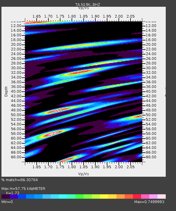
| Estimated Moho Depth: |
57.75 km |
| Estimated Crust Vp/Vs: |
1.72 |
| Assumed Crust Vp: |
6.566 km/s |
| Estimated Crust Vs: |
3.818 km/s |
| Estimated Crust Poisson's Ratio: |
0.24 |
|
| Radial Match: |
86.30784 % |
| Radial Bump: |
400 |
| Transverse Match: |
75.38435 % |
| Transverse Bump: |
400 |
| SOD ConfigId: |
11737051 |
| Insert Time: |
2019-04-25 15:24:14.378 +0000 |
| GWidth: |
2.5 |
| Max Bumps: |
400 |
| Tol: |
0.001 |
|

Signal To Noise
| Channel | StoN | STA | LTA |
| TA:N19K: :BHZ:20160924T21:39:32.075012Z | 13.715636 | 3.7048424E-6 | 2.7011816E-7 |
| TA:N19K: :BHN:20160924T21:39:32.075012Z | 8.417153 | 1.7204549E-6 | 2.0439866E-7 |
| TA:N19K: :BHE:20160924T21:39:32.075012Z | 2.8911147 | 9.1330014E-7 | 3.1589894E-7 |
| Arrivals |
| Ps | 6.5 SECOND |
| PpPs | 23 SECOND |
| PsPs/PpSs | 30 SECOND |


