You are here: Home > Network List > NE - New England Seismic Network Stations List
> Station BRYW Smithfield, RI, USA > Earthquake Result Viewer
BRYW Smithfield, RI, USA - Earthquake Result Viewer
| Earthquake location: |
Near Coast Of Central Chile |
| Earthquake latitude/longitude: |
-30.8/-71.4 |
| Earthquake time(UTC): |
2015/09/26 (269) 02:51:18 GMT |
| Earthquake Depth: |
38 km |
| Earthquake Magnitude: |
6.2 MO |
| Earthquake Catalog/Contributor: |
NEIC PDE/NEIC ALERT |
|
| Network: |
NE New England Seismic Network |
| Station: |
BRYW Smithfield, RI, USA |
| Lat/Lon: |
41.92 N/71.54 W |
| Elevation: |
116 m |
|
| Distance: |
72.4 deg |
| Az: |
359.881 deg |
| Baz: |
179.862 deg |
| Ray Param: |
0.05363899 |
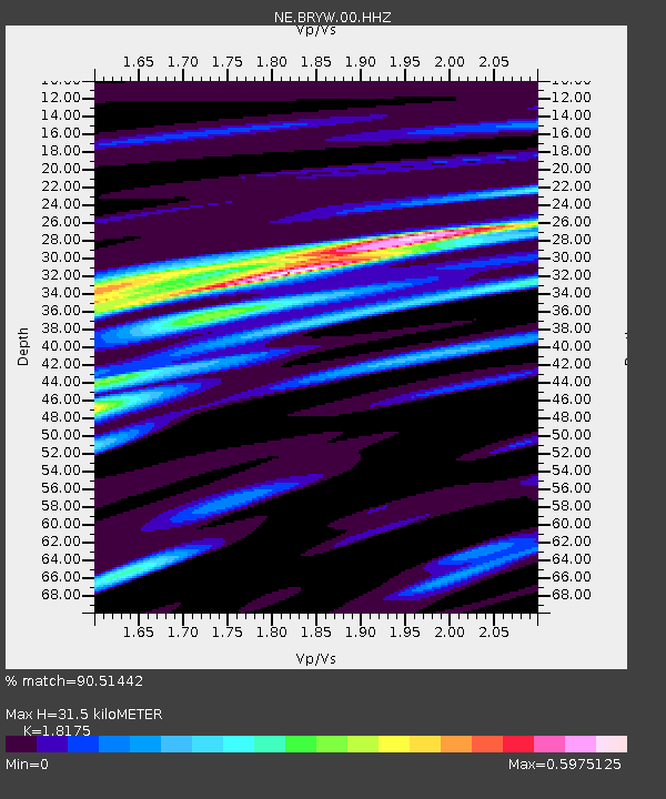
| Estimated Moho Depth: |
31.5 km |
| Estimated Crust Vp/Vs: |
1.82 |
| Assumed Crust Vp: |
6.472 km/s |
| Estimated Crust Vs: |
3.561 km/s |
| Estimated Crust Poisson's Ratio: |
0.28 |
|
| Radial Match: |
90.51442 % |
| Radial Bump: |
263 |
| Transverse Match: |
77.28336 % |
| Transverse Bump: |
367 |
| SOD ConfigId: |
1156111 |
| Insert Time: |
2015-10-10 03:30:05.917 +0000 |
| GWidth: |
2.5 |
| Max Bumps: |
400 |
| Tol: |
0.001 |
|

Signal To Noise
| Channel | StoN | STA | LTA |
| NE:BRYW:00:HHZ:20150926T03:02:09.364978Z | 16.493362 | 4.6676523E-6 | 2.8300187E-7 |
| NE:BRYW:00:HH1:20150926T03:02:09.364978Z | 12.8456955 | 2.2850127E-6 | 1.7788159E-7 |
| NE:BRYW:00:HH2:20150926T03:02:09.364978Z | 2.6363497 | 7.0714555E-7 | 2.6822903E-7 |
| Arrivals |
| Ps | 4.1 SECOND |
| PpPs | 13 SECOND |
| PsPs/PpSs | 17 SECOND |


