You are here: Home > Network List > UW - Pacific Northwest Regional Seismic Network Stations List
> Station DOSE Dosewallips old TA.C04A, WA > Earthquake Result Viewer
DOSE Dosewallips old TA.C04A, WA - Earthquake Result Viewer
| Earthquake location: |
Fiji Islands Region |
| Earthquake latitude/longitude: |
-19.8/-178.3 |
| Earthquake time(UTC): |
2016/09/24 (268) 21:28:42 GMT |
| Earthquake Depth: |
594 km |
| Earthquake Magnitude: |
6.8 MO |
| Earthquake Catalog/Contributor: |
NEIC PDE/NEIC ALERT |
|
| Network: |
UW Pacific Northwest Regional Seismic Network |
| Station: |
DOSE Dosewallips old TA.C04A, WA |
| Lat/Lon: |
47.72 N/122.97 W |
| Elevation: |
53 m |
|
| Distance: |
83.5 deg |
| Az: |
33.968 deg |
| Baz: |
231.163 deg |
| Ray Param: |
0.044368904 |
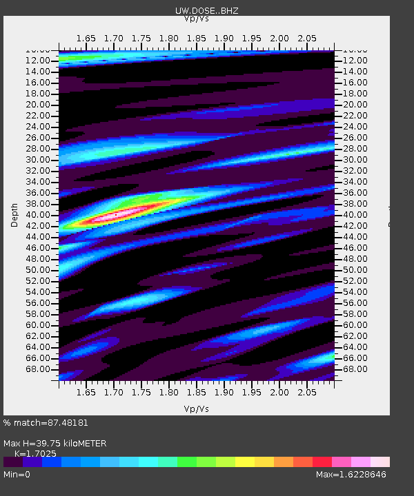
| Estimated Moho Depth: |
39.75 km |
| Estimated Crust Vp/Vs: |
1.70 |
| Assumed Crust Vp: |
6.566 km/s |
| Estimated Crust Vs: |
3.857 km/s |
| Estimated Crust Poisson's Ratio: |
0.24 |
|
| Radial Match: |
87.48181 % |
| Radial Bump: |
400 |
| Transverse Match: |
85.968864 % |
| Transverse Bump: |
400 |
| SOD ConfigId: |
11737051 |
| Insert Time: |
2019-04-25 15:25:19.204 +0000 |
| GWidth: |
2.5 |
| Max Bumps: |
400 |
| Tol: |
0.001 |
|

Signal To Noise
| Channel | StoN | STA | LTA |
| UW:DOSE: :BHZ:20160924T21:39:36.390015Z | 12.633185 | 1.5140486E-6 | 1.1984693E-7 |
| UW:DOSE: :BHN:20160924T21:39:36.390015Z | 2.5403106 | 4.848676E-7 | 1.9086941E-7 |
| UW:DOSE: :BHE:20160924T21:39:36.390015Z | 2.761284 | 4.3622163E-7 | 1.5797782E-7 |
| Arrivals |
| Ps | 4.4 SECOND |
| PpPs | 16 SECOND |
| PsPs/PpSs | 20 SECOND |


