You are here: Home > Network List > UW - Pacific Northwest Regional Seismic Network Stations List
> Station FISH Seaside, OR, USA > Earthquake Result Viewer
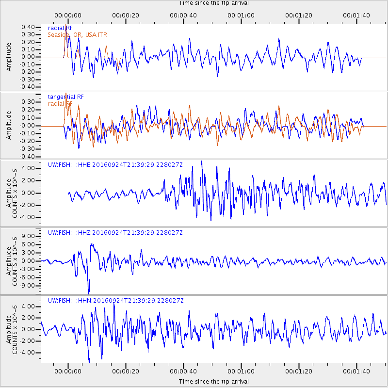
FISH Seaside, OR, USA - Earthquake Result Viewer
*The percent match for this event was below the threshold and hence no stack was calculated.
| Earthquake location: |
Fiji Islands Region |
| Earthquake latitude/longitude: |
-19.8/-178.3 |
| Earthquake time(UTC): |
2016/09/24 (268) 21:28:42 GMT |
| Earthquake Depth: |
594 km |
| Earthquake Magnitude: |
6.8 MO |
| Earthquake Catalog/Contributor: |
NEIC PDE/NEIC ALERT |
|
| Network: |
UW Pacific Northwest Regional Seismic Network |
| Station: |
FISH Seaside, OR, USA |
| Lat/Lon: |
45.93 N/123.56 W |
| Elevation: |
325 m |
|
| Distance: |
82.1 deg |
| Az: |
35.113 deg |
| Baz: |
230.879 deg |
| Ray Param: |
$rayparam |
*The percent match for this event was below the threshold and hence was not used in the summary stack. |
|
| Radial Match: |
72.702965 % |
| Radial Bump: |
400 |
| Transverse Match: |
71.71531 % |
| Transverse Bump: |
400 |
| SOD ConfigId: |
11737051 |
| Insert Time: |
2019-04-25 15:25:22.843 +0000 |
| GWidth: |
2.5 |
| Max Bumps: |
400 |
| Tol: |
0.001 |
|
Signal To Noise
| Channel | StoN | STA | LTA |
| UW:FISH: :HHZ:20160924T21:39:29.228027Z | 4.4088936 | 2.4218998E-6 | 5.4932144E-7 |
| UW:FISH: :HHN:20160924T21:39:29.228027Z | 1.1758211 | 9.696198E-7 | 8.2463214E-7 |
| UW:FISH: :HHE:20160924T21:39:29.228027Z | 1.5181961 | 7.5567937E-7 | 4.977482E-7 |
| Arrivals |
| Ps | |
| PpPs | |
| PsPs/PpSs | |


