You are here: Home > Network List > UW - Pacific Northwest Regional Seismic Network Stations List
> Station MRBL Marblemount, WA, USA > Earthquake Result Viewer
MRBL Marblemount, WA, USA - Earthquake Result Viewer
| Earthquake location: |
Fiji Islands Region |
| Earthquake latitude/longitude: |
-19.8/-178.3 |
| Earthquake time(UTC): |
2016/09/24 (268) 21:28:42 GMT |
| Earthquake Depth: |
594 km |
| Earthquake Magnitude: |
6.8 MO |
| Earthquake Catalog/Contributor: |
NEIC PDE/NEIC ALERT |
|
| Network: |
UW Pacific Northwest Regional Seismic Network |
| Station: |
MRBL Marblemount, WA, USA |
| Lat/Lon: |
48.52 N/121.48 W |
| Elevation: |
75 m |
|
| Distance: |
84.8 deg |
| Az: |
33.956 deg |
| Baz: |
232.265 deg |
| Ray Param: |
0.04348687 |
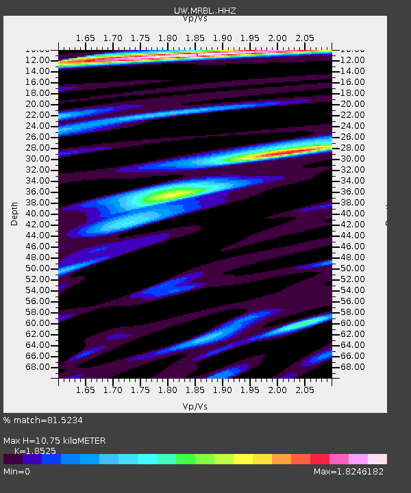
| Estimated Moho Depth: |
10.75 km |
| Estimated Crust Vp/Vs: |
1.85 |
| Assumed Crust Vp: |
6.566 km/s |
| Estimated Crust Vs: |
3.544 km/s |
| Estimated Crust Poisson's Ratio: |
0.29 |
|
| Radial Match: |
81.5234 % |
| Radial Bump: |
400 |
| Transverse Match: |
74.934105 % |
| Transverse Bump: |
400 |
| SOD ConfigId: |
11737051 |
| Insert Time: |
2019-04-25 15:25:33.051 +0000 |
| GWidth: |
2.5 |
| Max Bumps: |
400 |
| Tol: |
0.001 |
|
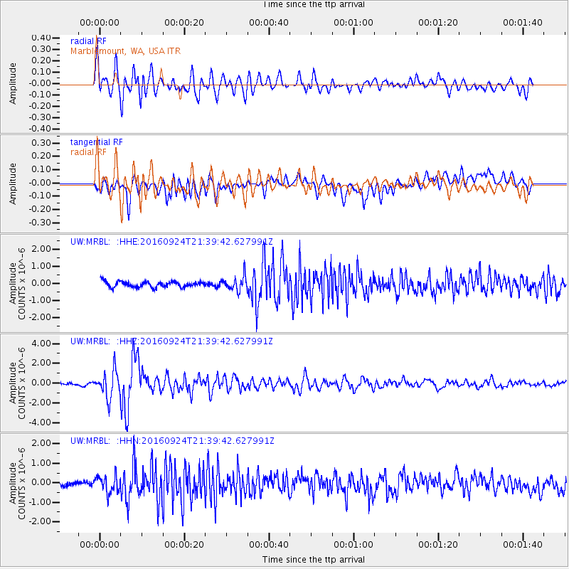
Signal To Noise
| Channel | StoN | STA | LTA |
| UW:MRBL: :HHZ:20160924T21:39:42.627991Z | 7.18631 | 1.4193043E-6 | 1.9750112E-7 |
| UW:MRBL: :HHN:20160924T21:39:42.627991Z | 3.3044622 | 4.3197673E-7 | 1.3072527E-7 |
| UW:MRBL: :HHE:20160924T21:39:42.627991Z | 2.9717693 | 4.5816475E-7 | 1.5417238E-7 |
| Arrivals |
| Ps | 1.4 SECOND |
| PpPs | 4.6 SECOND |
| PsPs/PpSs | 6.0 SECOND |


