You are here: Home > Network List > NE - New England Seismic Network Stations List
> Station WSPT Westport, CT, USA > Earthquake Result Viewer
WSPT Westport, CT, USA - Earthquake Result Viewer
| Earthquake location: |
Near Coast Of Central Chile |
| Earthquake latitude/longitude: |
-30.8/-71.4 |
| Earthquake time(UTC): |
2015/09/26 (269) 02:51:18 GMT |
| Earthquake Depth: |
38 km |
| Earthquake Magnitude: |
6.2 MO |
| Earthquake Catalog/Contributor: |
NEIC PDE/NEIC ALERT |
|
| Network: |
NE New England Seismic Network |
| Station: |
WSPT Westport, CT, USA |
| Lat/Lon: |
41.17 N/73.33 W |
| Elevation: |
91 m |
|
| Distance: |
71.7 deg |
| Az: |
358.455 deg |
| Baz: |
178.24 deg |
| Ray Param: |
0.05412095 |
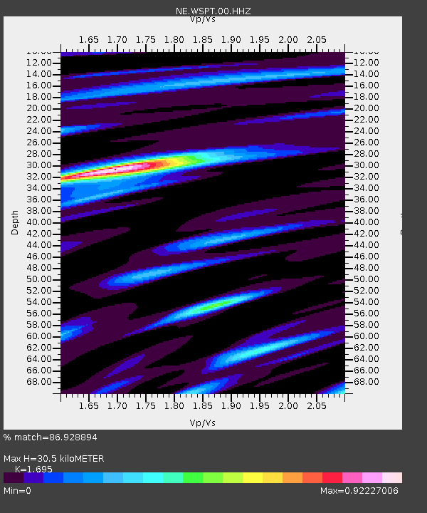
| Estimated Moho Depth: |
30.5 km |
| Estimated Crust Vp/Vs: |
1.70 |
| Assumed Crust Vp: |
6.472 km/s |
| Estimated Crust Vs: |
3.818 km/s |
| Estimated Crust Poisson's Ratio: |
0.23 |
|
| Radial Match: |
86.928894 % |
| Radial Bump: |
359 |
| Transverse Match: |
77.02158 % |
| Transverse Bump: |
400 |
| SOD ConfigId: |
1156111 |
| Insert Time: |
2015-10-10 03:30:57.498 +0000 |
| GWidth: |
2.5 |
| Max Bumps: |
400 |
| Tol: |
0.001 |
|

Signal To Noise
| Channel | StoN | STA | LTA |
| NE:WSPT:00:HHZ:20150926T03:02:05.048999Z | 10.040028 | 4.8774855E-6 | 4.85804E-7 |
| NE:WSPT:00:HH1:20150926T03:02:05.048999Z | 6.4458838 | 2.0163998E-6 | 3.1281976E-7 |
| NE:WSPT:00:HH2:20150926T03:02:05.048999Z | 4.0461507 | 1.0060986E-6 | 2.4865574E-7 |
| Arrivals |
| Ps | 3.4 SECOND |
| PpPs | 12 SECOND |
| PsPs/PpSs | 16 SECOND |


