You are here: Home > Network List > YT07 - POLENET Stations List
> Station ALYS ALYS > Earthquake Result Viewer
ALYS ALYS - Earthquake Result Viewer
| Earthquake location: |
Fiji Islands Region |
| Earthquake latitude/longitude: |
-19.8/-178.3 |
| Earthquake time(UTC): |
2016/09/24 (268) 21:28:42 GMT |
| Earthquake Depth: |
594 km |
| Earthquake Magnitude: |
6.8 MO |
| Earthquake Catalog/Contributor: |
NEIC PDE/NEIC ALERT |
|
| Network: |
YT POLENET |
| Station: |
ALYS ALYS |
| Lat/Lon: |
84.35 S/23.73 W |
| Elevation: |
2084 m |
|
| Distance: |
75.4 deg |
| Az: |
177.479 deg |
| Baz: |
204.721 deg |
| Ray Param: |
0.049737602 |
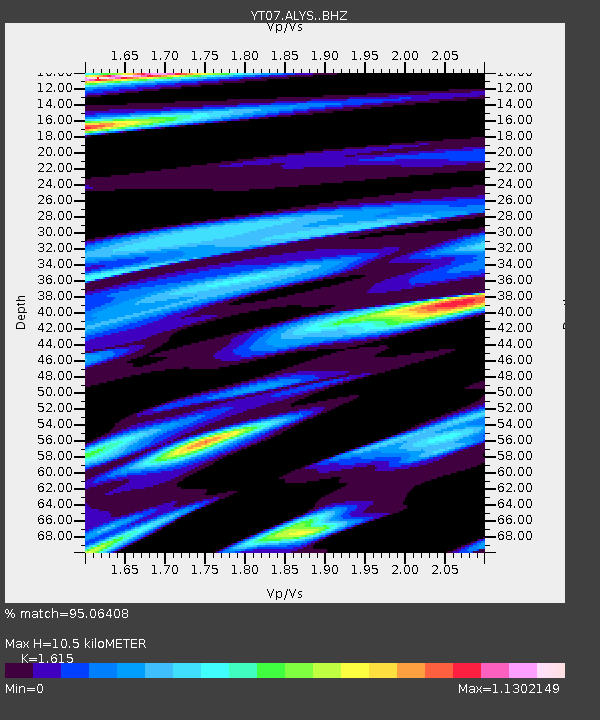
| Estimated Moho Depth: |
10.5 km |
| Estimated Crust Vp/Vs: |
1.62 |
| Assumed Crust Vp: |
6.356 km/s |
| Estimated Crust Vs: |
3.936 km/s |
| Estimated Crust Poisson's Ratio: |
0.19 |
|
| Radial Match: |
95.06408 % |
| Radial Bump: |
400 |
| Transverse Match: |
83.7363 % |
| Transverse Bump: |
400 |
| SOD ConfigId: |
11737051 |
| Insert Time: |
2019-04-25 15:26:50.453 +0000 |
| GWidth: |
2.5 |
| Max Bumps: |
400 |
| Tol: |
0.001 |
|

Signal To Noise
| Channel | StoN | STA | LTA |
| YT:ALYS: :BHZ:20160924T21:38:54.823975Z | 45.902676 | 1.1907819E-5 | 2.594145E-7 |
| YT:ALYS: :BHN:20160924T21:38:54.823975Z | 16.0498 | 4.7733147E-6 | 2.974065E-7 |
| YT:ALYS: :BHE:20160924T21:38:54.823975Z | 7.9234257 | 2.6359533E-6 | 3.3267847E-7 |
| Arrivals |
| Ps | 1.0 SECOND |
| PpPs | 4.2 SECOND |
| PsPs/PpSs | 5.2 SECOND |


