You are here: Home > Network List > US - United States National Seismic Network Stations List
> Station ELK Elko, Nevada, USA > Earthquake Result Viewer
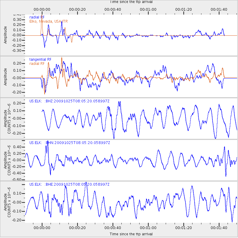
ELK Elko, Nevada, USA - Earthquake Result Viewer
*The percent match for this event was below the threshold and hence no stack was calculated.
| Earthquake location: |
South Of Fiji Islands |
| Earthquake latitude/longitude: |
-23.1/-179.2 |
| Earthquake time(UTC): |
2009/10/25 (298) 07:53:52 GMT |
| Earthquake Depth: |
418 km |
| Earthquake Magnitude: |
5.6 MB, 6.0 MW, 5.9 MW |
| Earthquake Catalog/Contributor: |
WHDF/NEIC |
|
| Network: |
US United States National Seismic Network |
| Station: |
ELK Elko, Nevada, USA |
| Lat/Lon: |
40.74 N/115.24 W |
| Elevation: |
2210 m |
|
| Distance: |
86.9 deg |
| Az: |
43.131 deg |
| Baz: |
235.954 deg |
| Ray Param: |
$rayparam |
*The percent match for this event was below the threshold and hence was not used in the summary stack. |
|
| Radial Match: |
68.98065 % |
| Radial Bump: |
303 |
| Transverse Match: |
42.36386 % |
| Transverse Bump: |
400 |
| SOD ConfigId: |
2622 |
| Insert Time: |
2010-03-05 07:20:58.849 +0000 |
| GWidth: |
2.5 |
| Max Bumps: |
400 |
| Tol: |
0.001 |
|
Signal To Noise
| Channel | StoN | STA | LTA |
| US:ELK: :BHN:20091025T08:05:20.058997Z | 3.1437566 | 2.7122775E-7 | 8.627505E-8 |
| US:ELK: :BHE:20091025T08:05:20.058997Z | 1.1086282 | 8.593367E-8 | 7.751352E-8 |
| US:ELK: :BHZ:20091025T08:05:20.058997Z | 0.9050423 | 6.722451E-8 | 7.427776E-8 |
| Arrivals |
| Ps | |
| PpPs | |
| PsPs/PpSs | |


