You are here: Home > Network List > US - United States National Seismic Network Stations List
> Station ACSO Alum Creek State Park, Ohio, USA > Earthquake Result Viewer
ACSO Alum Creek State Park, Ohio, USA - Earthquake Result Viewer

| Earthquake location: |
Near Coast Of Central Chile |
| Earthquake latitude/longitude: |
-30.8/-71.4 |
| Earthquake time(UTC): |
2015/09/26 (269) 02:51:18 GMT |
| Earthquake Depth: |
38 km |
| Earthquake Magnitude: |
6.2 MO |
| Earthquake Catalog/Contributor: |
NEIC PDE/NEIC ALERT |
|
| Network: |
US United States National Seismic Network |
| Station: |
ACSO Alum Creek State Park, Ohio, USA |
| Lat/Lon: |
40.23 N/82.98 W |
| Elevation: |
288 m |
|
| Distance: |
71.5 deg |
| Az: |
350.661 deg |
| Baz: |
169.493 deg |
| Ray Param: |
0.054218862 |
| Estimated Moho Depth: |
46.25 km |
| Estimated Crust Vp/Vs: |
1.81 |
| Assumed Crust Vp: |
6.498 km/s |
| Estimated Crust Vs: |
3.585 km/s |
| Estimated Crust Poisson's Ratio: |
0.28 |
|
| Radial Match: |
96.74482 % |
| Radial Bump: |
296 |
| Transverse Match: |
71.85131 % |
| Transverse Bump: |
394 |
| SOD ConfigId: |
1156111 |
| Insert Time: |
2015-10-10 03:32:45.182 +0000 |
| GWidth: |
2.5 |
| Max Bumps: |
400 |
| Tol: |
0.001 |
|
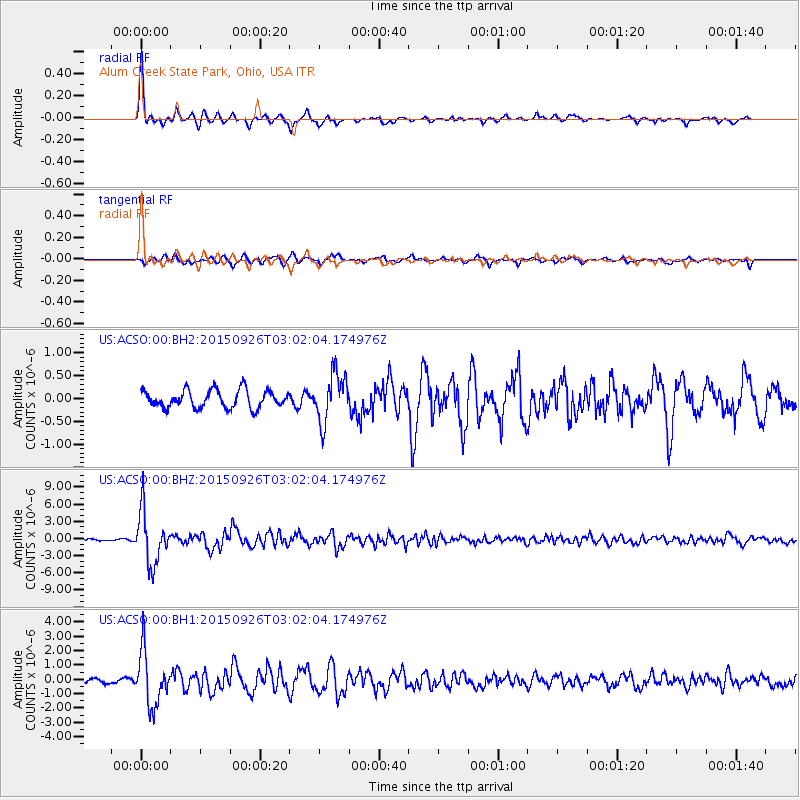
Signal To Noise
| Channel | StoN | STA | LTA |
| US:ACSO:00:BHZ:20150926T03:02:04.174976Z | 21.176687 | 4.512119E-6 | 2.1307011E-7 |
| US:ACSO:00:BH1:20150926T03:02:04.174976Z | 13.206692 | 1.8606225E-6 | 1.4088484E-7 |
| US:ACSO:00:BH2:20150926T03:02:04.174976Z | 2.7125242 | 5.244764E-7 | 1.9335363E-7 |
| Arrivals |
| Ps | 6.0 SECOND |
| PpPs | 19 SECOND |
| PsPs/PpSs | 25 SECOND |


