You are here: Home > Network List > US - United States National Seismic Network Stations List
> Station ELK Elko, Nevada, USA > Earthquake Result Viewer
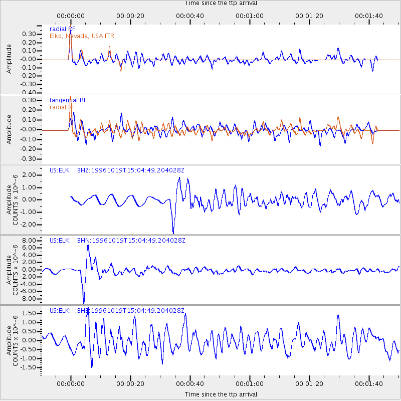
ELK Elko, Nevada, USA - Earthquake Result Viewer
*The percent match for this event was below the threshold and hence no stack was calculated.
| Earthquake location: |
Fiji Islands Region |
| Earthquake latitude/longitude: |
-20.4/-178.5 |
| Earthquake time(UTC): |
1996/10/19 (293) 14:53:48 GMT |
| Earthquake Depth: |
591 km |
| Earthquake Magnitude: |
6.1 MB, 6.9 UNKNOWN, 6.8 MW |
| Earthquake Catalog/Contributor: |
WHDF/NEIC |
|
| Network: |
US United States National Seismic Network |
| Station: |
ELK Elko, Nevada, USA |
| Lat/Lon: |
40.74 N/115.24 W |
| Elevation: |
2210 m |
|
| Distance: |
84.5 deg |
| Az: |
42.976 deg |
| Baz: |
237.305 deg |
| Ray Param: |
$rayparam |
*The percent match for this event was below the threshold and hence was not used in the summary stack. |
|
| Radial Match: |
77.556335 % |
| Radial Bump: |
358 |
| Transverse Match: |
78.47491 % |
| Transverse Bump: |
399 |
| SOD ConfigId: |
4480 |
| Insert Time: |
2010-03-05 07:21:01.953 +0000 |
| GWidth: |
2.5 |
| Max Bumps: |
400 |
| Tol: |
0.001 |
|
Signal To Noise
| Channel | StoN | STA | LTA |
| US:ELK: :BHN:19961019T15:04:49.204028Z | 5.0486407 | 2.9654698E-6 | 5.873798E-7 |
| US:ELK: :BHE:19961019T15:04:49.204028Z | 1.5145937 | 4.3404532E-7 | 2.865754E-7 |
| US:ELK: :BHZ:19961019T15:04:49.204028Z | 2.891876 | 8.6252953E-7 | 2.9825952E-7 |
| Arrivals |
| Ps | |
| PpPs | |
| PsPs/PpSs | |


