You are here: Home > Network List > AV - Alaska Volcano Observatory Stations List
> Station SPCR Ckakachatna River, Mount Spurr, Alaska > Earthquake Result Viewer
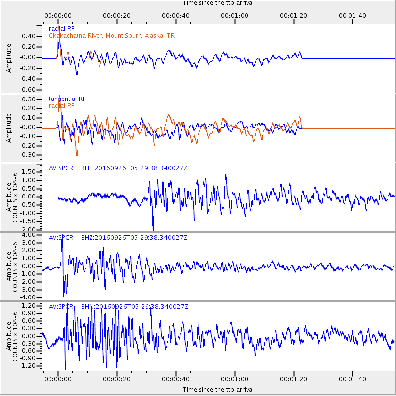
SPCR Ckakachatna River, Mount Spurr, Alaska - Earthquake Result Viewer
*The percent match for this event was below the threshold and hence no stack was calculated.
| Earthquake location: |
Ryukyu Islands, Japan |
| Earthquake latitude/longitude: |
27.5/128.6 |
| Earthquake time(UTC): |
2016/09/26 (270) 05:19:58 GMT |
| Earthquake Depth: |
40 km |
| Earthquake Magnitude: |
6.0 MB |
| Earthquake Catalog/Contributor: |
NEIC PDE/NEIC ALERT |
|
| Network: |
AV Alaska Volcano Observatory |
| Station: |
SPCR Ckakachatna River, Mount Spurr, Alaska |
| Lat/Lon: |
61.20 N/152.21 W |
| Elevation: |
984 m |
|
| Distance: |
61.2 deg |
| Az: |
32.881 deg |
| Baz: |
275.038 deg |
| Ray Param: |
$rayparam |
*The percent match for this event was below the threshold and hence was not used in the summary stack. |
|
| Radial Match: |
75.19257 % |
| Radial Bump: |
355 |
| Transverse Match: |
73.16198 % |
| Transverse Bump: |
400 |
| SOD ConfigId: |
11737051 |
| Insert Time: |
2019-04-25 15:35:54.273 +0000 |
| GWidth: |
2.5 |
| Max Bumps: |
400 |
| Tol: |
0.001 |
|
Signal To Noise
| Channel | StoN | STA | LTA |
| AV:SPCR: :BHZ:20160926T05:29:38.340027Z | 10.124029 | 1.7542081E-6 | 1.7327174E-7 |
| AV:SPCR: :BHN:20160926T05:29:38.340027Z | 3.1279902 | 4.5037606E-7 | 1.4398258E-7 |
| AV:SPCR: :BHE:20160926T05:29:38.340027Z | 3.7704163 | 6.467606E-7 | 1.7153559E-7 |
| Arrivals |
| Ps | |
| PpPs | |
| PsPs/PpSs | |


