You are here: Home > Network List > CI - Caltech Regional Seismic Network Stations List
> Station MPM Manuel Prospect Mine, California, USA > Earthquake Result Viewer
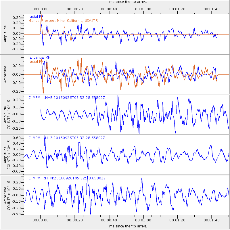
MPM Manuel Prospect Mine, California, USA - Earthquake Result Viewer
*The percent match for this event was below the threshold and hence no stack was calculated.
| Earthquake location: |
Ryukyu Islands, Japan |
| Earthquake latitude/longitude: |
27.5/128.6 |
| Earthquake time(UTC): |
2016/09/26 (270) 05:19:58 GMT |
| Earthquake Depth: |
40 km |
| Earthquake Magnitude: |
6.0 MB |
| Earthquake Catalog/Contributor: |
NEIC PDE/NEIC ALERT |
|
| Network: |
CI Caltech Regional Seismic Network |
| Station: |
MPM Manuel Prospect Mine, California, USA |
| Lat/Lon: |
36.06 N/117.49 W |
| Elevation: |
185 m |
|
| Distance: |
91.3 deg |
| Az: |
47.793 deg |
| Baz: |
305.686 deg |
| Ray Param: |
$rayparam |
*The percent match for this event was below the threshold and hence was not used in the summary stack. |
|
| Radial Match: |
56.874783 % |
| Radial Bump: |
400 |
| Transverse Match: |
51.521797 % |
| Transverse Bump: |
400 |
| SOD ConfigId: |
11737051 |
| Insert Time: |
2019-04-25 15:36:59.871 +0000 |
| GWidth: |
2.5 |
| Max Bumps: |
400 |
| Tol: |
0.001 |
|
Signal To Noise
| Channel | StoN | STA | LTA |
| CI:MPM: :HHZ:20160926T05:32:28.65802Z | 3.2224069 | 2.6814143E-7 | 8.321154E-8 |
| CI:MPM: :HHN:20160926T05:32:28.65802Z | 1.4134083 | 1.0040221E-7 | 7.103554E-8 |
| CI:MPM: :HHE:20160926T05:32:28.65802Z | 2.0284386 | 8.913964E-8 | 4.3944954E-8 |
| Arrivals |
| Ps | |
| PpPs | |
| PsPs/PpSs | |


