You are here: Home > Network List > CI - Caltech Regional Seismic Network Stations List
> Station MPP McPhearson Peak > Earthquake Result Viewer
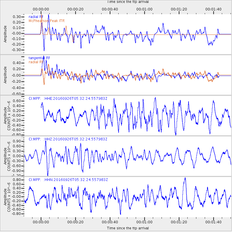
MPP McPhearson Peak - Earthquake Result Viewer
*The percent match for this event was below the threshold and hence no stack was calculated.
| Earthquake location: |
Ryukyu Islands, Japan |
| Earthquake latitude/longitude: |
27.5/128.6 |
| Earthquake time(UTC): |
2016/09/26 (270) 05:19:58 GMT |
| Earthquake Depth: |
40 km |
| Earthquake Magnitude: |
6.0 MB |
| Earthquake Catalog/Contributor: |
NEIC PDE/NEIC ALERT |
|
| Network: |
CI Caltech Regional Seismic Network |
| Station: |
MPP McPhearson Peak |
| Lat/Lon: |
34.89 N/119.81 W |
| Elevation: |
1739 m |
|
| Distance: |
90.5 deg |
| Az: |
49.838 deg |
| Baz: |
304.311 deg |
| Ray Param: |
$rayparam |
*The percent match for this event was below the threshold and hence was not used in the summary stack. |
|
| Radial Match: |
54.542713 % |
| Radial Bump: |
400 |
| Transverse Match: |
62.63606 % |
| Transverse Bump: |
400 |
| SOD ConfigId: |
11737051 |
| Insert Time: |
2019-04-25 15:37:00.870 +0000 |
| GWidth: |
2.5 |
| Max Bumps: |
400 |
| Tol: |
0.001 |
|
Signal To Noise
| Channel | StoN | STA | LTA |
| CI:MPP: :HHZ:20160926T05:32:24.557983Z | 2.3748732 | 5.382336E-7 | 2.2663679E-7 |
| CI:MPP: :HHN:20160926T05:32:24.557983Z | 0.571775 | 1.5275585E-7 | 2.6716077E-7 |
| CI:MPP: :HHE:20160926T05:32:24.557983Z | 1.080534 | 2.2376501E-7 | 2.0708742E-7 |
| Arrivals |
| Ps | |
| PpPs | |
| PsPs/PpSs | |


