You are here: Home > Network List > TA - USArray Transportable Network (new EarthScope stations) Stations List
> Station A21K Barrow, AK, USA > Earthquake Result Viewer
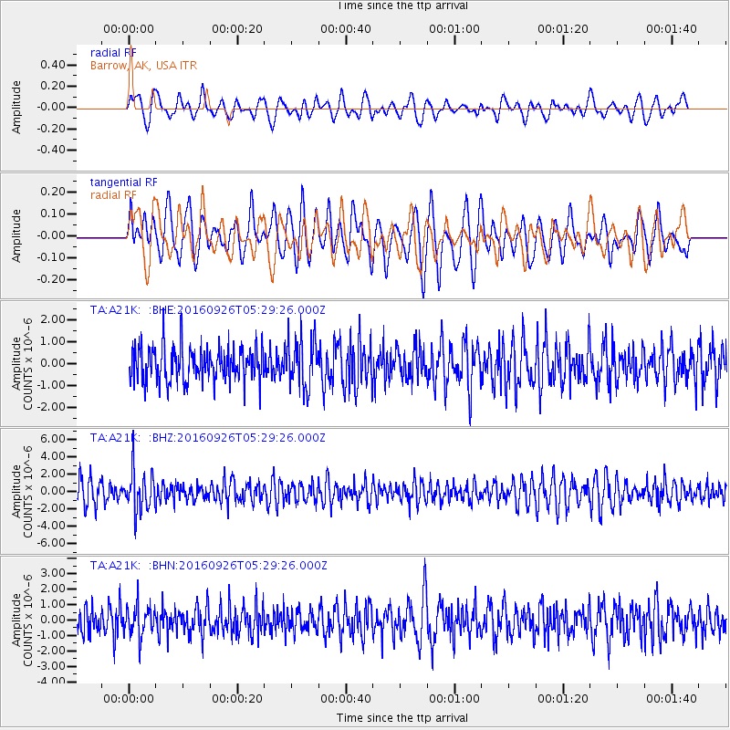
A21K Barrow, AK, USA - Earthquake Result Viewer
*The percent match for this event was below the threshold and hence no stack was calculated.
| Earthquake location: |
Ryukyu Islands, Japan |
| Earthquake latitude/longitude: |
27.5/128.6 |
| Earthquake time(UTC): |
2016/09/26 (270) 05:19:58 GMT |
| Earthquake Depth: |
40 km |
| Earthquake Magnitude: |
6.0 MB |
| Earthquake Catalog/Contributor: |
NEIC PDE/NEIC ALERT |
|
| Network: |
TA USArray Transportable Network (new EarthScope stations) |
| Station: |
A21K Barrow, AK, USA |
| Lat/Lon: |
71.32 N/156.62 W |
| Elevation: |
577 m |
|
| Distance: |
59.4 deg |
| Az: |
21.182 deg |
| Baz: |
265.175 deg |
| Ray Param: |
$rayparam |
*The percent match for this event was below the threshold and hence was not used in the summary stack. |
|
| Radial Match: |
52.52661 % |
| Radial Bump: |
400 |
| Transverse Match: |
57.692505 % |
| Transverse Bump: |
400 |
| SOD ConfigId: |
11737051 |
| Insert Time: |
2019-04-25 15:42:27.760 +0000 |
| GWidth: |
2.5 |
| Max Bumps: |
400 |
| Tol: |
0.001 |
|
Signal To Noise
| Channel | StoN | STA | LTA |
| TA:A21K: :BHZ:20160926T05:29:26.000Z | 2.0642433 | 2.25245E-6 | 1.0911747E-6 |
| TA:A21K: :BHN:20160926T05:29:26.000Z | 1.2884221 | 9.983701E-7 | 7.7487806E-7 |
| TA:A21K: :BHE:20160926T05:29:26.000Z | 1.4400523 | 1.1421831E-6 | 7.931539E-7 |
| Arrivals |
| Ps | |
| PpPs | |
| PsPs/PpSs | |


