You are here: Home > Network List > TA - USArray Transportable Network (new EarthScope stations) Stations List
> Station C27K Jago River, AK, USA > Earthquake Result Viewer
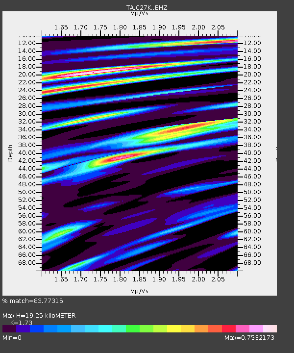
C27K Jago River, AK, USA - Earthquake Result Viewer
| Earthquake location: |
Ryukyu Islands, Japan |
| Earthquake latitude/longitude: |
27.5/128.6 |
| Earthquake time(UTC): |
2016/09/26 (270) 05:19:58 GMT |
| Earthquake Depth: |
40 km |
| Earthquake Magnitude: |
6.0 MB |
| Earthquake Catalog/Contributor: |
NEIC PDE/NEIC ALERT |
|
| Network: |
TA USArray Transportable Network (new EarthScope stations) |
| Station: |
C27K Jago River, AK, USA |
| Lat/Lon: |
69.63 N/143.71 W |
| Elevation: |
392 m |
|
| Distance: |
63.8 deg |
| Az: |
22.963 deg |
| Baz: |
278.186 deg |
| Ray Param: |
0.059290845 |
| Estimated Moho Depth: |
19.25 km |
| Estimated Crust Vp/Vs: |
1.73 |
| Assumed Crust Vp: |
6.522 km/s |
| Estimated Crust Vs: |
3.77 km/s |
| Estimated Crust Poisson's Ratio: |
0.25 |
|
| Radial Match: |
83.77315 % |
| Radial Bump: |
400 |
| Transverse Match: |
86.03958 % |
| Transverse Bump: |
400 |
| SOD ConfigId: |
11737051 |
| Insert Time: |
2019-04-25 15:42:30.233 +0000 |
| GWidth: |
2.5 |
| Max Bumps: |
400 |
| Tol: |
0.001 |
|

Signal To Noise
| Channel | StoN | STA | LTA |
| TA:C27K: :BHZ:20160926T05:29:55.474976Z | 13.142648 | 1.4113202E-6 | 1.0738477E-7 |
| TA:C27K: :BHN:20160926T05:29:55.474976Z | 3.0470045 | 2.7313237E-7 | 8.9639634E-8 |
| TA:C27K: :BHE:20160926T05:29:55.474976Z | 7.090712 | 5.757182E-7 | 8.119329E-8 |
| Arrivals |
| Ps | 2.3 SECOND |
| PpPs | 7.7 SECOND |
| PsPs/PpSs | 10.0 SECOND |


