You are here: Home > Network List > TA - USArray Transportable Network (new EarthScope stations) Stations List
> Station F21K Alatna River, AK, USA > Earthquake Result Viewer
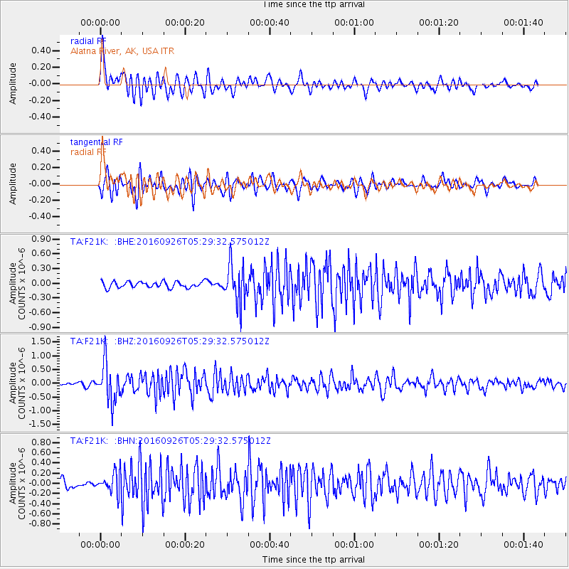
F21K Alatna River, AK, USA - Earthquake Result Viewer
*The percent match for this event was below the threshold and hence no stack was calculated.
| Earthquake location: |
Ryukyu Islands, Japan |
| Earthquake latitude/longitude: |
27.5/128.6 |
| Earthquake time(UTC): |
2016/09/26 (270) 05:19:58 GMT |
| Earthquake Depth: |
40 km |
| Earthquake Magnitude: |
6.0 MB |
| Earthquake Catalog/Contributor: |
NEIC PDE/NEIC ALERT |
|
| Network: |
TA USArray Transportable Network (new EarthScope stations) |
| Station: |
F21K Alatna River, AK, USA |
| Lat/Lon: |
67.22 N/153.48 W |
| Elevation: |
597 m |
|
| Distance: |
60.3 deg |
| Az: |
25.99 deg |
| Baz: |
270.522 deg |
| Ray Param: |
$rayparam |
*The percent match for this event was below the threshold and hence was not used in the summary stack. |
|
| Radial Match: |
68.13298 % |
| Radial Bump: |
400 |
| Transverse Match: |
61.6404 % |
| Transverse Bump: |
400 |
| SOD ConfigId: |
11737051 |
| Insert Time: |
2019-04-25 15:42:44.218 +0000 |
| GWidth: |
2.5 |
| Max Bumps: |
400 |
| Tol: |
0.001 |
|
Signal To Noise
| Channel | StoN | STA | LTA |
| TA:F21K: :BHZ:20160926T05:29:32.575012Z | 9.99175 | 7.040097E-7 | 7.04591E-8 |
| TA:F21K: :BHN:20160926T05:29:32.575012Z | 2.9191482 | 1.997267E-7 | 6.841951E-8 |
| TA:F21K: :BHE:20160926T05:29:32.575012Z | 6.338745 | 3.8841281E-7 | 6.1275976E-8 |
| Arrivals |
| Ps | |
| PpPs | |
| PsPs/PpSs | |


