You are here: Home > Network List > TA - USArray Transportable Network (new EarthScope stations) Stations List
> Station G21K Allakaket, AK, USA > Earthquake Result Viewer
G21K Allakaket, AK, USA - Earthquake Result Viewer

| Earthquake location: |
Ryukyu Islands, Japan |
| Earthquake latitude/longitude: |
27.5/128.6 |
| Earthquake time(UTC): |
2016/09/26 (270) 05:19:58 GMT |
| Earthquake Depth: |
40 km |
| Earthquake Magnitude: |
6.0 MB |
| Earthquake Catalog/Contributor: |
NEIC PDE/NEIC ALERT |
|
| Network: |
TA USArray Transportable Network (new EarthScope stations) |
| Station: |
G21K Allakaket, AK, USA |
| Lat/Lon: |
66.52 N/153.51 W |
| Elevation: |
446 m |
|
| Distance: |
60.3 deg |
| Az: |
26.807 deg |
| Baz: |
270.905 deg |
| Ray Param: |
0.061516453 |
| Estimated Moho Depth: |
13.0 km |
| Estimated Crust Vp/Vs: |
1.60 |
| Assumed Crust Vp: |
6.455 km/s |
| Estimated Crust Vs: |
4.028 km/s |
| Estimated Crust Poisson's Ratio: |
0.18 |
|
| Radial Match: |
85.6059 % |
| Radial Bump: |
400 |
| Transverse Match: |
79.84025 % |
| Transverse Bump: |
400 |
| SOD ConfigId: |
11737051 |
| Insert Time: |
2019-04-25 15:42:50.243 +0000 |
| GWidth: |
2.5 |
| Max Bumps: |
400 |
| Tol: |
0.001 |
|
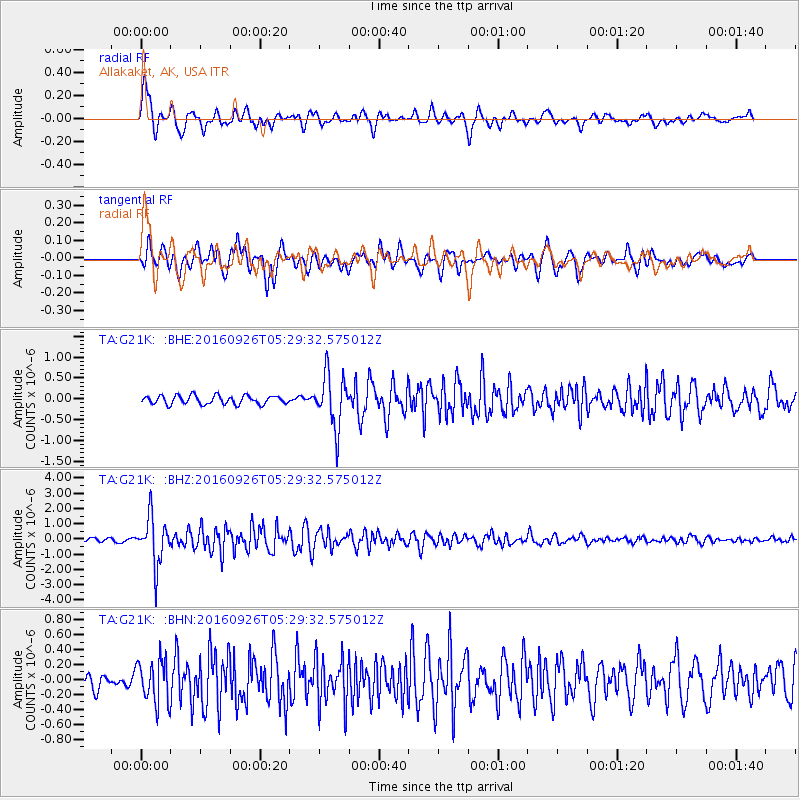
Signal To Noise
| Channel | StoN | STA | LTA |
| TA:G21K: :BHZ:20160926T05:29:32.575012Z | 16.107372 | 1.5517803E-6 | 9.633975E-8 |
| TA:G21K: :BHN:20160926T05:29:32.575012Z | 3.2613003 | 2.8060907E-7 | 8.604208E-8 |
| TA:G21K: :BHE:20160926T05:29:32.575012Z | 6.124472 | 6.301744E-7 | 1.0289448E-7 |
| Arrivals |
| Ps | 1.3 SECOND |
| PpPs | 5.0 SECOND |
| PsPs/PpSs | 6.3 SECOND |


