You are here: Home > Network List > TA - USArray Transportable Network (new EarthScope stations) Stations List
> Station H21K Melozitna River, AK, USA > Earthquake Result Viewer
H21K Melozitna River, AK, USA - Earthquake Result Viewer
| Earthquake location: |
Ryukyu Islands, Japan |
| Earthquake latitude/longitude: |
27.5/128.6 |
| Earthquake time(UTC): |
2016/09/26 (270) 05:19:58 GMT |
| Earthquake Depth: |
40 km |
| Earthquake Magnitude: |
6.0 MB |
| Earthquake Catalog/Contributor: |
NEIC PDE/NEIC ALERT |
|
| Network: |
TA USArray Transportable Network (new EarthScope stations) |
| Station: |
H21K Melozitna River, AK, USA |
| Lat/Lon: |
65.66 N/152.80 W |
| Elevation: |
520 m |
|
| Distance: |
60.6 deg |
| Az: |
27.789 deg |
| Baz: |
272.029 deg |
| Ray Param: |
0.061313327 |
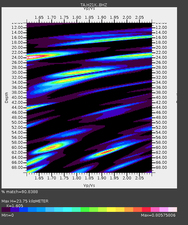
| Estimated Moho Depth: |
23.75 km |
| Estimated Crust Vp/Vs: |
1.61 |
| Assumed Crust Vp: |
6.566 km/s |
| Estimated Crust Vs: |
4.091 km/s |
| Estimated Crust Poisson's Ratio: |
0.18 |
|
| Radial Match: |
90.8388 % |
| Radial Bump: |
354 |
| Transverse Match: |
79.96293 % |
| Transverse Bump: |
400 |
| SOD ConfigId: |
11737051 |
| Insert Time: |
2019-04-25 15:42:57.439 +0000 |
| GWidth: |
2.5 |
| Max Bumps: |
400 |
| Tol: |
0.001 |
|

Signal To Noise
| Channel | StoN | STA | LTA |
| TA:H21K: :BHZ:20160926T05:29:34.674988Z | 16.76162 | 1.2482113E-6 | 7.446842E-8 |
| TA:H21K: :BHN:20160926T05:29:34.674988Z | 3.3504338 | 2.317178E-7 | 6.9160535E-8 |
| TA:H21K: :BHE:20160926T05:29:34.674988Z | 7.8025556 | 7.484579E-7 | 9.592472E-8 |
| Arrivals |
| Ps | 2.3 SECOND |
| PpPs | 8.9 SECOND |
| PsPs/PpSs | 11 SECOND |


