You are here: Home > Network List > TA - USArray Transportable Network (new EarthScope stations) Stations List
> Station L20K Farewell, AK, USA > Earthquake Result Viewer
L20K Farewell, AK, USA - Earthquake Result Viewer
| Earthquake location: |
Ryukyu Islands, Japan |
| Earthquake latitude/longitude: |
27.5/128.6 |
| Earthquake time(UTC): |
2016/09/26 (270) 05:19:58 GMT |
| Earthquake Depth: |
40 km |
| Earthquake Magnitude: |
6.0 MB |
| Earthquake Catalog/Contributor: |
NEIC PDE/NEIC ALERT |
|
| Network: |
TA USArray Transportable Network (new EarthScope stations) |
| Station: |
L20K Farewell, AK, USA |
| Lat/Lon: |
62.48 N/153.88 W |
| Elevation: |
673 m |
|
| Distance: |
60.3 deg |
| Az: |
31.477 deg |
| Baz: |
272.881 deg |
| Ray Param: |
0.061534915 |
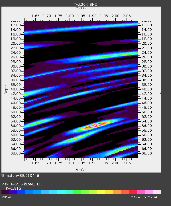
| Estimated Moho Depth: |
55.5 km |
| Estimated Crust Vp/Vs: |
1.91 |
| Assumed Crust Vp: |
6.566 km/s |
| Estimated Crust Vs: |
3.429 km/s |
| Estimated Crust Poisson's Ratio: |
0.31 |
|
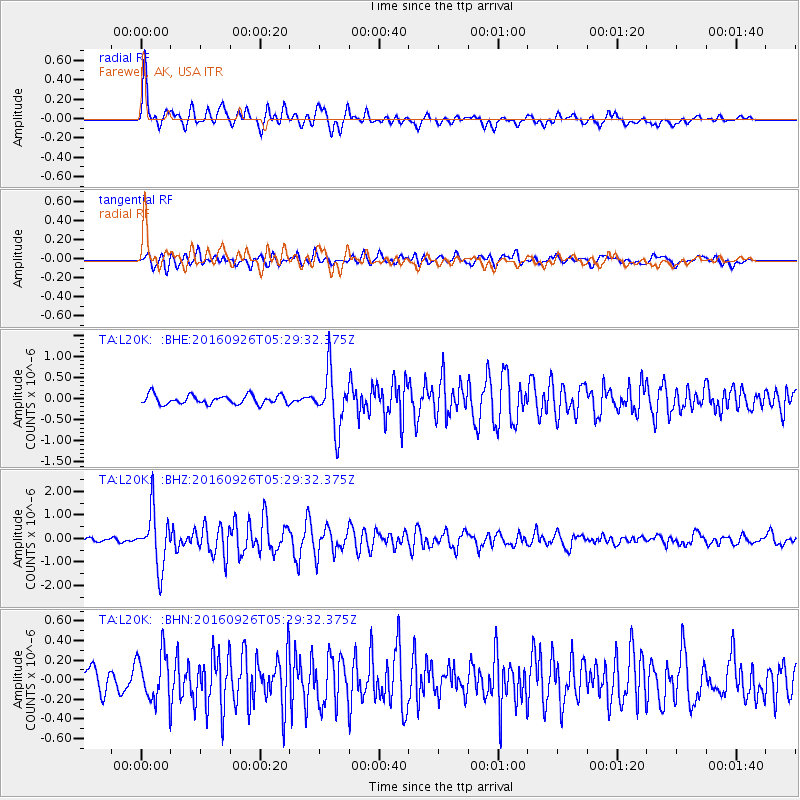
| Radial Match: |
88.910446 % |
| Radial Bump: |
400 |
| Transverse Match: |
73.737366 % |
| Transverse Bump: |
400 |
| SOD ConfigId: |
11737051 |
| Insert Time: |
2019-04-25 15:43:22.622 +0000 |
| GWidth: |
2.5 |
| Max Bumps: |
400 |
| Tol: |
0.001 |
|
Signal To Noise
| Channel | StoN | STA | LTA |
| TA:L20K: :BHZ:20160926T05:29:32.375Z | 11.216473 | 1.1603911E-6 | 1.0345419E-7 |
| TA:L20K: :BHN:20160926T05:29:32.375Z | 2.078072 | 2.496878E-7 | 1.2015356E-7 |
| TA:L20K: :BHE:20160926T05:29:32.375Z | 6.195845 | 6.6004367E-7 | 1.0653005E-7 |
| Arrivals |
| Ps | 8.1 SECOND |
| PpPs | 24 SECOND |
| PsPs/PpSs | 32 SECOND |


