You are here: Home > Network List > TA - USArray Transportable Network (new EarthScope stations) Stations List
> Station MDND Maddock, ND, USA > Earthquake Result Viewer
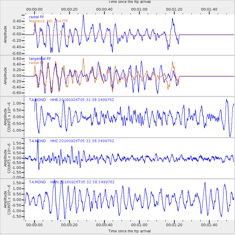
MDND Maddock, ND, USA - Earthquake Result Viewer
*The percent match for this event was below the threshold and hence no stack was calculated.
| Earthquake location: |
Ryukyu Islands, Japan |
| Earthquake latitude/longitude: |
27.5/128.6 |
| Earthquake time(UTC): |
2016/09/26 (270) 05:19:58 GMT |
| Earthquake Depth: |
40 km |
| Earthquake Magnitude: |
6.0 MB |
| Earthquake Catalog/Contributor: |
NEIC PDE/NEIC ALERT |
|
| Network: |
TA USArray Transportable Network (new EarthScope stations) |
| Station: |
MDND Maddock, ND, USA |
| Lat/Lon: |
47.85 N/99.60 W |
| Elevation: |
479 m |
|
| Distance: |
93.4 deg |
| Az: |
30.182 deg |
| Baz: |
318.458 deg |
| Ray Param: |
$rayparam |
*The percent match for this event was below the threshold and hence was not used in the summary stack. |
|
| Radial Match: |
42.994904 % |
| Radial Bump: |
395 |
| Transverse Match: |
61.82353 % |
| Transverse Bump: |
386 |
| SOD ConfigId: |
11737051 |
| Insert Time: |
2019-04-25 15:43:32.856 +0000 |
| GWidth: |
2.5 |
| Max Bumps: |
400 |
| Tol: |
0.001 |
|
Signal To Noise
| Channel | StoN | STA | LTA |
| TA:MDND: :HHZ:20160926T05:32:38.349976Z | 4.4034414 | 6.1141367E-7 | 1.3884905E-7 |
| TA:MDND: :HHN:20160926T05:32:38.349976Z | 0.8157904 | 4.021965E-7 | 4.930145E-7 |
| TA:MDND: :HHE:20160926T05:32:38.349976Z | 0.45508766 | 2.465736E-7 | 5.4181555E-7 |
| Arrivals |
| Ps | |
| PpPs | |
| PsPs/PpSs | |


