You are here: Home > Network List > TA - USArray Transportable Network (new EarthScope stations) Stations List
> Station M31M Drury Creek, Yukon, CA > Earthquake Result Viewer
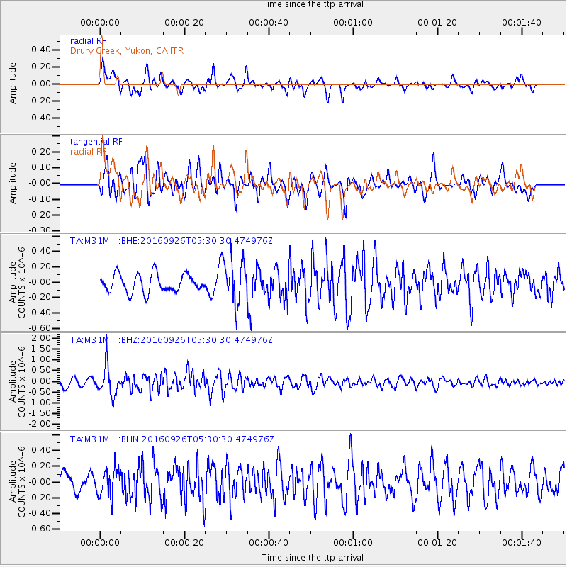
M31M Drury Creek, Yukon, CA - Earthquake Result Viewer
*The percent match for this event was below the threshold and hence no stack was calculated.
| Earthquake location: |
Ryukyu Islands, Japan |
| Earthquake latitude/longitude: |
27.5/128.6 |
| Earthquake time(UTC): |
2016/09/26 (270) 05:19:58 GMT |
| Earthquake Depth: |
40 km |
| Earthquake Magnitude: |
6.0 MB |
| Earthquake Catalog/Contributor: |
NEIC PDE/NEIC ALERT |
|
| Network: |
TA USArray Transportable Network (new EarthScope stations) |
| Station: |
M31M Drury Creek, Yukon, CA |
| Lat/Lon: |
62.20 N/134.39 W |
| Elevation: |
639 m |
|
| Distance: |
69.3 deg |
| Az: |
29.836 deg |
| Baz: |
289.452 deg |
| Ray Param: |
$rayparam |
*The percent match for this event was below the threshold and hence was not used in the summary stack. |
|
| Radial Match: |
65.169876 % |
| Radial Bump: |
400 |
| Transverse Match: |
70.61989 % |
| Transverse Bump: |
400 |
| SOD ConfigId: |
11737051 |
| Insert Time: |
2019-04-25 15:43:32.920 +0000 |
| GWidth: |
2.5 |
| Max Bumps: |
400 |
| Tol: |
0.001 |
|
Signal To Noise
| Channel | StoN | STA | LTA |
| TA:M31M: :BHZ:20160926T05:30:30.474976Z | 3.9073064 | 6.9261307E-7 | 1.77261E-7 |
| TA:M31M: :BHN:20160926T05:30:30.474976Z | 1.3278912 | 1.6960168E-7 | 1.2772256E-7 |
| TA:M31M: :BHE:20160926T05:30:30.474976Z | 2.5475073 | 2.9925306E-7 | 1.1746898E-7 |
| Arrivals |
| Ps | |
| PpPs | |
| PsPs/PpSs | |


