You are here: Home > Network List > TA - USArray Transportable Network (new EarthScope stations) Stations List
> Station R33M Jennings River, BC, CAN > Earthquake Result Viewer
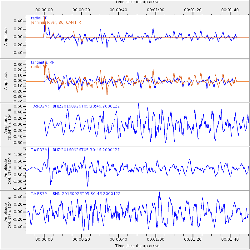
R33M Jennings River, BC, CAN - Earthquake Result Viewer
*The percent match for this event was below the threshold and hence no stack was calculated.
| Earthquake location: |
Ryukyu Islands, Japan |
| Earthquake latitude/longitude: |
27.5/128.6 |
| Earthquake time(UTC): |
2016/09/26 (270) 05:19:58 GMT |
| Earthquake Depth: |
40 km |
| Earthquake Magnitude: |
6.0 MB |
| Earthquake Catalog/Contributor: |
NEIC PDE/NEIC ALERT |
|
| Network: |
TA USArray Transportable Network (new EarthScope stations) |
| Station: |
R33M Jennings River, BC, CAN |
| Lat/Lon: |
59.39 N/130.97 W |
| Elevation: |
1437 m |
|
| Distance: |
71.8 deg |
| Az: |
31.972 deg |
| Baz: |
293.148 deg |
| Ray Param: |
$rayparam |
*The percent match for this event was below the threshold and hence was not used in the summary stack. |
|
| Radial Match: |
57.428555 % |
| Radial Bump: |
400 |
| Transverse Match: |
49.064037 % |
| Transverse Bump: |
400 |
| SOD ConfigId: |
11737051 |
| Insert Time: |
2019-04-25 15:44:01.157 +0000 |
| GWidth: |
2.5 |
| Max Bumps: |
400 |
| Tol: |
0.001 |
|
Signal To Noise
| Channel | StoN | STA | LTA |
| TA:R33M: :BHZ:20160926T05:30:46.200012Z | 4.4172063 | 6.214386E-7 | 1.4068588E-7 |
| TA:R33M: :BHN:20160926T05:30:46.200012Z | 1.1734031 | 1.5637559E-7 | 1.3326672E-7 |
| TA:R33M: :BHE:20160926T05:30:46.200012Z | 1.3287382 | 2.4934303E-7 | 1.87654E-7 |
| Arrivals |
| Ps | |
| PpPs | |
| PsPs/PpSs | |


