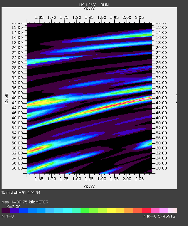
LONY Lake Ozonia, New York, USA - Earthquake Result Viewer
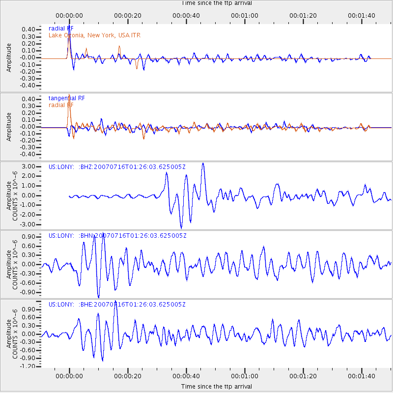
Earthquake location: Near West Coast Of Honshu, Japan
Earthquake latitude/longitude: 37.5/138.4
Earthquake time(UTC): 2007/07/16 (197) 01:13:22 GMT
Earthquake Depth: 12 km
Earthquake Magnitude: 6.5 MB, 6.4 MS, 6.6 MW, 6.5 MW
Earthquake Catalog/Contributor: WHDF/NEIC
Network: US United States National Seismic Network
Station: LONY Lake Ozonia, New York, USA
Lat/Lon: 44.62 N/74.58 W
Elevation: 440 m
Distance: 92.9 deg
Az: 22.94 deg
Baz: 334.287 deg
Ray Param: 0.04135832
Estimated Moho Depth: 39.75 km
Estimated Crust Vp/Vs: 2.09
Assumed Crust Vp: 6.419 km/s
Estimated Crust Vs: 3.071 km/s
Estimated Crust Poisson's Ratio: 0.35
Radial Match: 91.19164 %
Radial Bump: 400
Transverse Match: 87.78593 %
Transverse Bump: 400
SOD ConfigId: 2564
Insert Time: 2010-03-05 07:22:40.057 +0000
GWidth: 2.5
Max Bumps: 400
Tol: 0.001

Signal To Noise

ChannelStoNSTALTA
US:LONY: :BHN:20070716T01:26:03.625005Z3.85554653.3666362E-78.73193E-8
US:LONY: :BHE:20070716T01:26:03.625005Z3.7924983.1810546E-78.387756E-8
US:LONY: :BHZ:20070716T01:26:03.625005Z10.0424061.0837002E-61.079124E-7
Arrivals
Ps6.9 SECOND
PpPs19 SECOND
PsPs/PpSs26 SECOND