You are here: Home > Network List > UW - Pacific Northwest Regional Seismic Network Stations List
> Station UMAT Pilot Rock, OR, USA > Earthquake Result Viewer
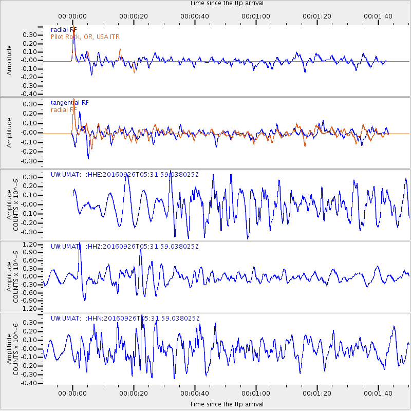
UMAT Pilot Rock, OR, USA - Earthquake Result Viewer
*The percent match for this event was below the threshold and hence no stack was calculated.
| Earthquake location: |
Ryukyu Islands, Japan |
| Earthquake latitude/longitude: |
27.5/128.6 |
| Earthquake time(UTC): |
2016/09/26 (270) 05:19:58 GMT |
| Earthquake Depth: |
40 km |
| Earthquake Magnitude: |
6.0 MB |
| Earthquake Catalog/Contributor: |
NEIC PDE/NEIC ALERT |
|
| Network: |
UW Pacific Northwest Regional Seismic Network |
| Station: |
UMAT Pilot Rock, OR, USA |
| Lat/Lon: |
45.29 N/118.96 W |
| Elevation: |
1318 m |
|
| Distance: |
85.1 deg |
| Az: |
40.892 deg |
| Baz: |
304.514 deg |
| Ray Param: |
$rayparam |
*The percent match for this event was below the threshold and hence was not used in the summary stack. |
|
| Radial Match: |
55.867683 % |
| Radial Bump: |
400 |
| Transverse Match: |
74.50123 % |
| Transverse Bump: |
400 |
| SOD ConfigId: |
11737051 |
| Insert Time: |
2019-04-25 15:44:52.475 +0000 |
| GWidth: |
2.5 |
| Max Bumps: |
400 |
| Tol: |
0.001 |
|
Signal To Noise
| Channel | StoN | STA | LTA |
| UW:UMAT: :HHZ:20160926T05:31:59.038025Z | 3.86386 | 5.254713E-7 | 1.3599646E-7 |
| UW:UMAT: :HHN:20160926T05:31:59.038025Z | 1.3744293 | 1.2171756E-7 | 8.8558615E-8 |
| UW:UMAT: :HHE:20160926T05:31:59.038025Z | 1.2963622 | 1.6815561E-7 | 1.2971346E-7 |
| Arrivals |
| Ps | |
| PpPs | |
| PsPs/PpSs | |


