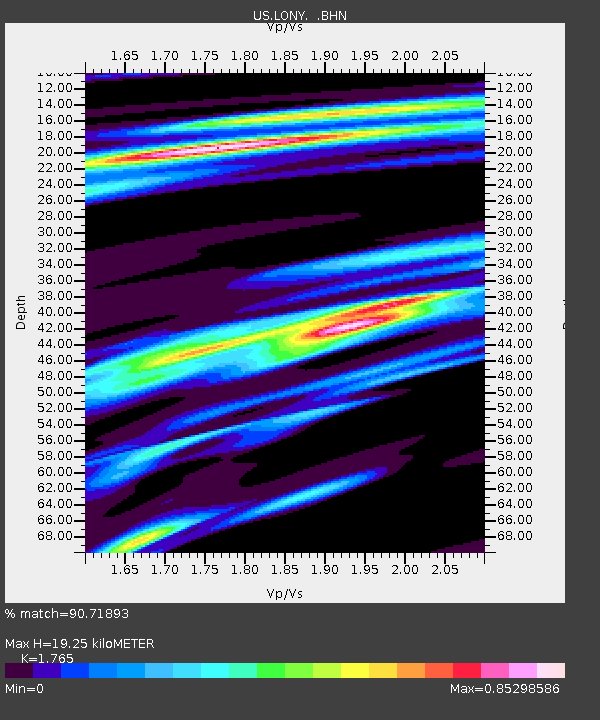
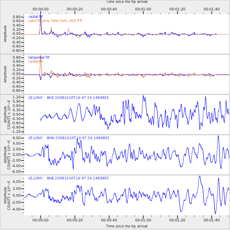
LONY Lake Ozonia, New York, USA - Earthquake Result Viewer

Earthquake location: Near Coast Of Chiapas, Mexico
Earthquake latitude/longitude: 14.4/-92.4
Earthquake time(UTC): 2008/10/16 (290) 19:41:25 GMT
Earthquake Depth: 24 km
Earthquake Magnitude: 6.1 MB, 6.6 MS, 6.7 MW, 6.6 MW
Earthquake Catalog/Contributor: WHDF/NEIC
Network: US United States National Seismic Network
Station: LONY Lake Ozonia, New York, USA
Lat/Lon: 44.62 N/74.58 W
Elevation: 440 m
Distance: 33.7 deg
Az: 23.156 deg
Baz: 212.243 deg
Ray Param: 0.078064114
Estimated Moho Depth: 19.25 km
Estimated Crust Vp/Vs: 1.76
Assumed Crust Vp: 6.419 km/s
Estimated Crust Vs: 3.637 km/s
Estimated Crust Poisson's Ratio: 0.26
Radial Match: 90.71893 %
Radial Bump: 286
Transverse Match: 78.542244 %
Transverse Bump: 379
SOD ConfigId: 2556
Insert Time: 2010-03-05 07:23:06.305 +0000
GWidth: 2.5
Max Bumps: 400
Tol: 0.001

Signal To Noise

ChannelStoNSTALTA
US:LONY: :BHN:20081016T19:47:34.148986Z6.73324162.1613237E-63.2099302E-7
US:LONY: :BHE:20081016T19:47:34.148986Z3.0589881.1403146E-63.727751E-7
US:LONY: :BHZ:20081016T19:47:34.148986Z1.4724024.0511642E-72.7513983E-7
Arrivals
Ps2.5 SECOND
PpPs7.7 SECOND
PsPs/PpSs10 SECOND