You are here: Home > Network List > US - United States National Seismic Network Stations List
> Station LONY Lake Ozonia, New York, USA > Earthquake Result Viewer
LONY Lake Ozonia, New York, USA - Earthquake Result Viewer
| Earthquake location: |
Norwegian Sea |
| Earthquake latitude/longitude: |
72.2/0.9 |
| Earthquake time(UTC): |
2009/08/20 (232) 06:35:04 GMT |
| Earthquake Depth: |
6.0 km |
| Earthquake Magnitude: |
5.9 MB, 5.7 MS, 6.0 MW, 6.0 MW |
| Earthquake Catalog/Contributor: |
WHDF/NEIC |
|
| Network: |
US United States National Seismic Network |
| Station: |
LONY Lake Ozonia, New York, USA |
| Lat/Lon: |
44.62 N/74.58 W |
| Elevation: |
440 m |
|
| Distance: |
43.9 deg |
| Az: |
273.762 deg |
| Baz: |
25.451 deg |
| Ray Param: |
0.072284855 |
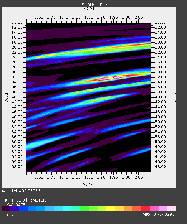
| Estimated Moho Depth: |
32.0 km |
| Estimated Crust Vp/Vs: |
1.95 |
| Assumed Crust Vp: |
6.419 km/s |
| Estimated Crust Vs: |
3.296 km/s |
| Estimated Crust Poisson's Ratio: |
0.32 |
|
| Radial Match: |
93.85256 % |
| Radial Bump: |
368 |
| Transverse Match: |
73.929436 % |
| Transverse Bump: |
371 |
| SOD ConfigId: |
2622 |
| Insert Time: |
2010-03-05 07:23:19.751 +0000 |
| GWidth: |
2.5 |
| Max Bumps: |
400 |
| Tol: |
0.001 |
|
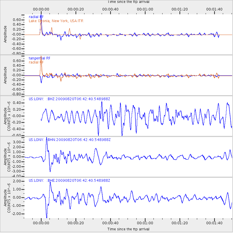
Signal To Noise
| Channel | StoN | STA | LTA |
| US:LONY: :BHN:20090820T06:42:40.548988Z | 18.015467 | 1.4733724E-6 | 8.178375E-8 |
| US:LONY: :BHE:20090820T06:42:40.548988Z | 13.521457 | 8.950015E-7 | 6.6191205E-8 |
| US:LONY: :BHZ:20090820T06:42:40.548988Z | 1.8335905 | 2.1374726E-7 | 1.16573055E-7 |
| Arrivals |
| Ps | 5.0 SECOND |
| PpPs | 14 SECOND |
| PsPs/PpSs | 19 SECOND |


