You are here: Home > Network List > UU - University of Utah Regional Network Stations List
> Station CCUT Cedar City, UT, USA > Earthquake Result Viewer
CCUT Cedar City, UT, USA - Earthquake Result Viewer

| Earthquake location: |
Near Coast Of Central Chile |
| Earthquake latitude/longitude: |
-30.8/-71.4 |
| Earthquake time(UTC): |
2015/09/26 (269) 02:51:18 GMT |
| Earthquake Depth: |
38 km |
| Earthquake Magnitude: |
6.2 MO |
| Earthquake Catalog/Contributor: |
NEIC PDE/NEIC ALERT |
|
| Network: |
UU University of Utah Regional Network |
| Station: |
CCUT Cedar City, UT, USA |
| Lat/Lon: |
37.55 N/113.36 W |
| Elevation: |
2127 m |
|
| Distance: |
78.5 deg |
| Az: |
327.151 deg |
| Baz: |
144.047 deg |
| Ray Param: |
0.049523037 |
| Estimated Moho Depth: |
33.5 km |
| Estimated Crust Vp/Vs: |
2.10 |
| Assumed Crust Vp: |
6.194 km/s |
| Estimated Crust Vs: |
2.953 km/s |
| Estimated Crust Poisson's Ratio: |
0.35 |
|
| Radial Match: |
88.98532 % |
| Radial Bump: |
399 |
| Transverse Match: |
80.54435 % |
| Transverse Bump: |
400 |
| SOD ConfigId: |
1156111 |
| Insert Time: |
2015-10-10 03:36:55.054 +0000 |
| GWidth: |
2.5 |
| Max Bumps: |
400 |
| Tol: |
0.001 |
|
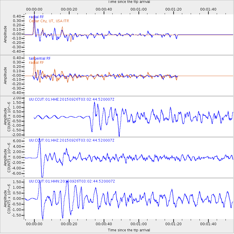
Signal To Noise
| Channel | StoN | STA | LTA |
| UU:CCUT:01:HHZ:20150926T03:02:44.520007Z | 61.24341 | 3.6195954E-6 | 5.9101794E-8 |
| UU:CCUT:01:HHN:20150926T03:02:44.520007Z | 7.2716956 | 8.021648E-7 | 1.1031331E-7 |
| UU:CCUT:01:HHE:20150926T03:02:44.520007Z | 8.065922 | 7.94865E-7 | 9.854608E-8 |
| Arrivals |
| Ps | 6.1 SECOND |
| PpPs | 16 SECOND |
| PsPs/PpSs | 22 SECOND |


