You are here: Home > Network List > TA - USArray Transportable Network (new EarthScope stations) Stations List
> Station D23K Nanushuk River, AK USA > Earthquake Result Viewer
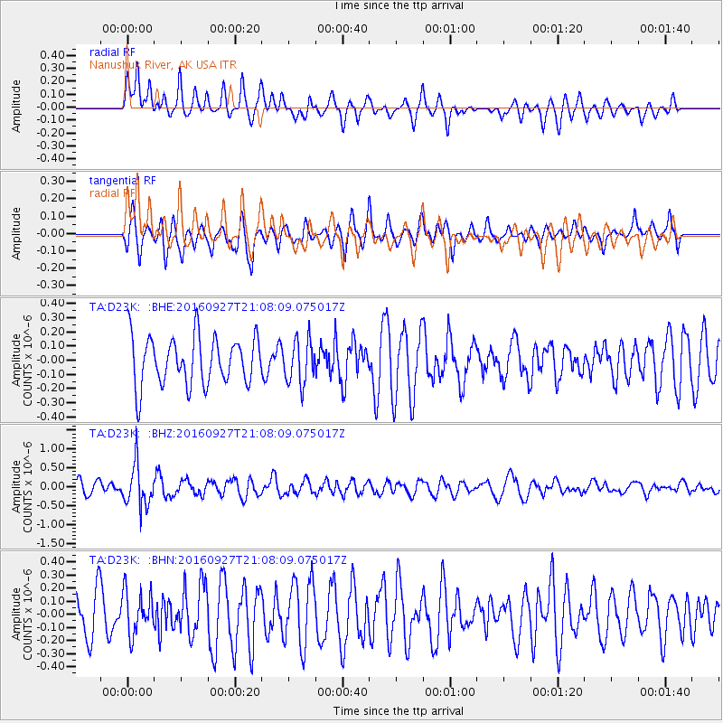
D23K Nanushuk River, AK USA - Earthquake Result Viewer
*The percent match for this event was below the threshold and hence no stack was calculated.
| Earthquake location: |
Dodecanese Islands, Greece |
| Earthquake latitude/longitude: |
36.4/27.6 |
| Earthquake time(UTC): |
2016/09/27 (271) 20:57:08 GMT |
| Earthquake Depth: |
85 km |
| Earthquake Magnitude: |
5.1 Mww |
| Earthquake Catalog/Contributor: |
NEIC PDE/us |
|
| Network: |
TA USArray Transportable Network (new EarthScope stations) |
| Station: |
D23K Nanushuk River, AK USA |
| Lat/Lon: |
68.97 N/150.68 W |
| Elevation: |
406 m |
|
| Distance: |
75.0 deg |
| Az: |
359.363 deg |
| Baz: |
1.425 deg |
| Ray Param: |
$rayparam |
*The percent match for this event was below the threshold and hence was not used in the summary stack. |
|
| Radial Match: |
54.5256 % |
| Radial Bump: |
400 |
| Transverse Match: |
57.64373 % |
| Transverse Bump: |
400 |
| SOD ConfigId: |
11737051 |
| Insert Time: |
2019-04-25 15:53:21.309 +0000 |
| GWidth: |
2.5 |
| Max Bumps: |
400 |
| Tol: |
0.001 |
|
Signal To Noise
| Channel | StoN | STA | LTA |
| TA:D23K: :BHZ:20160927T21:08:09.075017Z | 3.5018032 | 5.610614E-7 | 1.6022072E-7 |
| TA:D23K: :BHN:20160927T21:08:09.075017Z | 0.98583066 | 1.6568066E-7 | 1.6806199E-7 |
| TA:D23K: :BHE:20160927T21:08:09.075017Z | 0.9082436 | 1.549226E-7 | 1.7057384E-7 |
| Arrivals |
| Ps | |
| PpPs | |
| PsPs/PpSs | |


