You are here: Home > Network List > TA - USArray Transportable Network (new EarthScope stations) Stations List
> Station G21K Allakaket, AK, USA > Earthquake Result Viewer
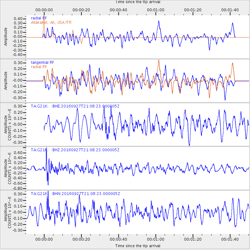
G21K Allakaket, AK, USA - Earthquake Result Viewer
*The percent match for this event was below the threshold and hence no stack was calculated.
| Earthquake location: |
Dodecanese Islands, Greece |
| Earthquake latitude/longitude: |
36.4/27.6 |
| Earthquake time(UTC): |
2016/09/27 (271) 20:57:08 GMT |
| Earthquake Depth: |
85 km |
| Earthquake Magnitude: |
5.1 Mww |
| Earthquake Catalog/Contributor: |
NEIC PDE/us |
|
| Network: |
TA USArray Transportable Network (new EarthScope stations) |
| Station: |
G21K Allakaket, AK, USA |
| Lat/Lon: |
66.52 N/153.51 W |
| Elevation: |
446 m |
|
| Distance: |
77.4 deg |
| Az: |
0.46 deg |
| Baz: |
359.074 deg |
| Ray Param: |
$rayparam |
*The percent match for this event was below the threshold and hence was not used in the summary stack. |
|
| Radial Match: |
50.73878 % |
| Radial Bump: |
400 |
| Transverse Match: |
62.384445 % |
| Transverse Bump: |
400 |
| SOD ConfigId: |
11737051 |
| Insert Time: |
2019-04-25 15:53:32.123 +0000 |
| GWidth: |
2.5 |
| Max Bumps: |
400 |
| Tol: |
0.001 |
|
Signal To Noise
| Channel | StoN | STA | LTA |
| TA:G21K: :BHZ:20160927T21:08:23.000005Z | 3.373232 | 2.6040502E-7 | 7.719749E-8 |
| TA:G21K: :BHN:20160927T21:08:23.000005Z | 1.0991921 | 1.09141936E-7 | 9.929286E-8 |
| TA:G21K: :BHE:20160927T21:08:23.000005Z | 1.0970846 | 1.2914312E-7 | 1.1771482E-7 |
| Arrivals |
| Ps | |
| PpPs | |
| PsPs/PpSs | |


